▪1708 - John & Francis Shackelford, born in Essex County, Virginia, settled on the west side of North River about 4 miles northeast of present-day Beaufort.
 |
| Capture of John Lawson |
%20-%20Copy.jpg)
▪1713 - John Shackelford and Enoch Ward purchased 7000 acres of "Sea Banks," then part of Bath County; Shackelford's portion became known as Shackleford Banks, the "el" transposed in the surname, beginning on early maps.
▪1714 - Farnifold Green's plantation near Oriental, was attacked, pillaged, and burned by Indians, resulting in the massacre of 40-year-old Green, son Thomas, a white servant and two Negroes. Another son was shot but escaped.
 |
| Queen Anne's Revenge |
▪1720 - Richard Rustull purchased the town land from Robert Turner.
▪1722 - Lords Proprietors appointed Beaufort as a port “for the unloading and discharging Vessels.”
▪1722 - Carteret Precinct was carved from Craven Precinct; Beaufort chosen as site of courthouse.
▪1723 - Beaufort Incorporated: Laws of North Carolina - An Act, for Incorporating the Seaport of Beaufort, In Carteret Precinct, Into a Township, by the Name of Beaufort.
▪1724 - Carteret deed books and court minutes referenced the First Courthouse - In June 1724, the church wardens bought from the town commissioners a ‘Lott of land...together with the house now erected thereon...being at present the house appointed for a Court House. Only 3 months later a hurricane rendered it unusable by destroying its roof; the next year it was completely destroyed by fire.
▪1724 - In June 1724, the trustees of Beaufort deeded Old Town Lot 91 [lot south and adjacent to present-day Purvis Chapel] "to the wardens of the Parish of St. Johns and the rest of the Vestrymen."
▪1725 - Nathaniel Taylor purchased the town from Richard Rustull.
 ▪1726 - Samuel Chadwick was issued the first whaling license in North Carolina.
▪1728 - Second Courthouse was built by William Davis; later site of Purvis Chapel (217 Craven Street).
▪1731 - Gov. Burrington described Beaufort as one of "little success & scarce any inhabitants." (Saunders: Colonial Records)
▪1731 - To enlarge the town Burial Ground, Nathaniel Taylor deeded Old Town Lot 81.
▪1733 - Thomas Martin purchased the town acreage from Nathaniel Taylor.
▪1733 - First Quaker Meeting in Carteret County at the home of William Borden, Harlowe Creek, north of Beaufort. Subsequent meetings were held at the home of Henry Stanton, on Core Creek, until a meeting house could be erected nearby.
 |
| 1733 Moseley Map noted Carrot Island |
▪1736-1776 - Whalers' camps were located on the beach west of Cape Lookout Bay.
▪1737 - John Brickell, writing in his Natural History of North Carolina, described Beaufort as a town of pleasant prospect but "small and thinly inhabited."
▪1737 - Beaufort's first prison was built and was used for 20 years; location unknown.
▪1739 - Carteret Precinct became Carteret County.
▪1737 - John Brickell, writing in his Natural History of North Carolina, described Beaufort as a town of pleasant prospect but "small and thinly inhabited."
▪1737 - Beaufort's first prison was built and was used for 20 years; location unknown.
▪1739 - Carteret Precinct became Carteret County.
▪1739 - John Pinder purchased the town acreage from Thomas Martin.
▪1742 - James Winwright bought the town from John Pinder. After Winwright’s death in 1744, there was no “owner” of Beaufort. Executors sold town properties to various individuals.
▪1747 - Spanish privateers captured town August 26; though details are lacking, it seems that the enemy was soon repulsed by the local militia.
▪1748 - Taxables (residents): 320 listed for Carteret County with about 32 in Beaufort.
▪1762 - Ferries were put into operation across the Newport and North Rivers.
 ▪1765 - Quaker Robert Williams sailed from England and purchased "Taylor's Old Field."
▪1765 - French visitor described Beaufort as "a small village not above 12 houses."
▪1765 - Caleb Davis operated an ordinary at his home on Cape Lookout Bay.
▪1771 - Samuel Guthrie operated a ferry to Cape Lookout fishing camps and dwellings.
▪1775-1783 - During the Revolutionary War, ships were in and out of Beaufort harbor transporting needed supplies. Patriots built salt works to supply themselves and others with the salt that had previously been imported. Some helped form an artillery battery to help defend the town. See: Carteret County During the American Revolution
▪1782 - Battle of Beaufort April 4-15; British plundered and skirmished with local militia.
▪1782 - "Water Street" became Front Street.
 ▪1783 - Spanish visitor Francisco de Miranda
wrote in his diary, “Beaufort is located on a sandy beach that, except
for some sandbanks, which act as a barrier against the sea and form the
sound, is quite unsheltered. It has about eighty inhabitants, and the
houses are very miserable..."
▪1783 - Spanish visitor Francisco de Miranda
wrote in his diary, “Beaufort is located on a sandy beach that, except
for some sandbanks, which act as a barrier against the sea and form the
sound, is quite unsheltered. It has about eighty inhabitants, and the
houses are very miserable..." ▪1794 - First Postmaster John M. Verdin; mail by horseback from New Bern.
▪1796 - Third Courthouse was built at the intersection of Ann and Turner Streets. Moved to 401 Ann in 1837 and converted into home, it was owned by descendants of Dr. William Cramer until acquired by the Beaufort Historical Association and moved to the Beaufort Restoration Grounds; fully restored in 1976.
▪1812 - James Davis built the first Market House.
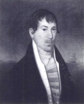 ▪1814 - Otway Burns, noted privateer during the War of 1812, built his home on Front Street between Pollock and Marsh Streets, where the Atlantic Hotel afterwards stood. His Beaufort shipyard built Prometheus, the first ship from NC to be powered solely by a steam engine. He also helped supply bricks for the building of Fort Macon. Burns remained in Beaufort until 1842.
▪1816 - RE-SURVEY OF TOWN - "...an ordinance of the Commissioners of the town of Beaufort, dated May 1816, that Jonathan Price should survey the town of Beaufort, and make a plat thereof...a private act of Assembly, entitled "an act to confirm an accurate survey of the town of Beaufort, in the county of Carteret, and for other purposes," which act recites that, "whereas, disputes have arisen concerning the true lines of the streets and lots of the town of Beaufort, in consequence of which the inhabitants have employed Jonathan Price to survey and make an accurate plan of the said town: Be it therefore enacted, and that the lines and plan of the town of Beaufort, as surveyed and established by Jonathan Price, shall hereafter be considered in all cases as the lines and plan of said town of Beaufort;" quoted from an 1853 court record Commissioners of Beaufort vs. Thomas Duncan.
▪1826-1834 - Fort Macon was constructed.
 ▪1820 - Purvis Chapel
was built. "According to the 1820 deed registered in the Court House,
one half acre lot 101, corner of Craven and Broad Streets, was purchased
from the town 'to be erected and built thereon a house of worship for
the use of the Methodist Episcopal Church in the United States of
America." (Muse). The chapel was deeded to black Methodists 1854.
▪1820 - Purvis Chapel
was built. "According to the 1820 deed registered in the Court House,
one half acre lot 101, corner of Craven and Broad Streets, was purchased
from the town 'to be erected and built thereon a house of worship for
the use of the Methodist Episcopal Church in the United States of
America." (Muse). The chapel was deeded to black Methodists 1854. 
▪1834 - Mail was delivered by stage coach, three times a week.
▪1837 - Fourth Courthouse was built by James Ward on Courthouse Square at the corner of Turner and Broad Streets.
 |
| Atlantic House Hotel |
▪1854 - Ann Street Methodist Church was built on the northwest corner of Ann and Craven Streets.
▪1854 - William Isaac Langdon conducted the Beaufort Female Institute at 505 Front Street in the house his mother built for him, the upper part to be used as his home, the basement rooms for the school.
▪1857 - Construction began on the chapel of St. Paul's Episcopal Church at 215 Ann Street. The Chapel was completed in 1865.
▪1858 - Railroad was completed from Goldsboro to Shepard's Point; passengers had to take ferries to Beaufort.
 ▪1862 - After the outbreak of the Civil War in 1861, the siege of Fort Macon by Union troops led by Gen. Ambrose Burnside took place on April 25, 1862. Beaufort residents watched from the waterfront. From March 1862 until August 1865 the town of Beaufort was occupied by Union forces.
 ▪1879 - August 17 hurricane destroyed the Atlantic House Hotel.
 |
| Seaside School |
▪1880-1886 - Johns Hopkins Marine Lab's "Seaside School" was located at the Gibbs House, 903 Front Street.
▪1881 - Mr. Charles Pittman Dey came to the area specifically for the purpose of starting a menhaden factory in Lennoxville. Dey's home was located on the east corner of Queen and Front Streets.
 |
| Davis House |
 |
| Beaufort High School |
 |
| Crissie Wright model by Jim Goodwin |
▪1887 - Signs and street lamps placed at street corners.
▪1888 - Large fire destroyed waterfront wharves, stores and warehouse.
▪1890s - Benjamin Leecraft Jones (home at 819 Broad Street) and Winfield Scott Chadwick became interested in the fish business and formed Carteret County Fish Oil and Guano Company. Chadwick's home (now a parking lot) was located on the west side of Turner Street, across from the Restoration Grounds.
▪1899-1901 - The U.S. FISH COMMISSION LAB was located at the Gibbs House, 903 Front Street.
▪ Early 1900s
̶ "At some elusive period early in this century, Beaufort changed considerably. Banker ponies were prohibited on the Town Marsh and Bird Shoal…no longer able to swim across the channel at low tide to graze along the sidewalks or run up and down the streets at night." (Amy Muse)
̶ Artesian wells replaced old town pumps.
̶ Picket fence around the Old Burying Ground was replaced with wall.
̶ Town gate and fence around the town gradually disappeared.
̶ U.S. Army Corp of Engineers began dredging Taylor's Creek.
 |
| C.C. Guthrie |
▪1902-1953 - The original Federal Fisheries Laboratory existed on Piver's Island; in 1953-54, the original building was replaced with a new more efficient laboratory.
▪1906 - The first train backed into town November 18, over new railroad bridge from Morehead City.
 ▪1907 - The Train Depot
was constructed at the corner of Broad and Pollock Streets. Starting
June 8, 1907, Gala Week celebrated the train coming to Beaufort.
▪1907 - The Train Depot
was constructed at the corner of Broad and Pollock Streets. Starting
June 8, 1907, Gala Week celebrated the train coming to Beaufort.
▪1907 - The fifth and current Courthouse replaced the 1837 Courthouse.
▪1910-11- The first library is thought to have started in the old 1837 courthouse building at the corner of Turner and Broad Streets.
▪1911 - Inland Waterway (first link) from Boston to Beaufort opened on January 6.
▪1911 - After moving from Smyrna to Beaufort about 1911, Luther Paul built and operated the "See Breeze Theater" on Front Street (current site of the North Carolina Maritime Museum).
 ▪1911 - Norcom House
was expanded by Charles Abernathy and named "New Inlet Inn; the inn was
torn down in 1967 for construction of BB&T building.
▪1911 - Norcom House
was expanded by Charles Abernathy and named "New Inlet Inn; the inn was
torn down in 1967 for construction of BB&T building.
▪1917 - Taylor’s Creek Fish Scrap & Oil Co., which began about 1917 had a continuous involvement in menhaden fishing until it closed in the early 1930s. Beaufort Fisheries replaced the outgoing factory and kept fishing in the sound until the mid-1990s.
▪1921 - Population 3000, free mail delivery began.
 ▪1927 - The first highway bridge, the "Twin City Bridge," was completed from the Atlantic Hotel in Morehead City to Ann Street in Beaufort.
▪1924 - Streets were first paved – sidewalks, new street lamps, sewer and water systems completed.
▪1926 - Confederate Memorial unveiled May 10.
▪1928 - First bridge was built from Morehead City to Atlantic Beach.
 ▪1937 - The Clarke-Duncan House
circa 1905 was moved from 701 Front Street eastward to 705 Front Street, to allow for construction of the Post Office. In 1939, Post Office murals were painted by Simka Simkhovitch.
▪1937 - The Clarke-Duncan House
circa 1905 was moved from 701 Front Street eastward to 705 Front Street, to allow for construction of the Post Office. In 1939, Post Office murals were painted by Simka Simkhovitch.
▪1940s - A bill approved by the NC Legislature gave Carteret County authority to maintain airport facilities. In 1942, the Civil Air Patrol established a base in Beaufort. In 1943, Coastal Patrol Base 21 began building runways in the West Beaufort area, which required dredging and raising the acreage above sea level. In 1946, the property was turned over to the county and leased to Earl Taylor and Bob Burrows, who started a flight school.
▪1957 - The Grayden Paul Bridge was constructed.
▪1957 - The First Homes Tour was sponsored by Beaufort Woman's Club, May 22.
▪1960 - The Beaufort Historical Association was incorporated.
▪1960 - The Beaufort Plaque was designed by Miss Elizabeth Merwin.
▪1960s - The Town Seal was designed by Will Hon.
▪1970s - A new causeway and high-rise bridge was built from Morehead City to Beaufort.
▪1970 - The Hampton Marine Museum opened on Turner Street in April.
▪1974 - The Beaufort Historic District was placed on the National Register of Historic Places.
▪1972 - Waterfront renewal began – sea wall, floating docks, public dock, retail stores, restaurants and parking replaced two blocks of old waterfront buildings.
▪1985 -The North Carolina Maritime Museum on Front Street opened May 18.
▪1985 - The State of North Carolina acquired Town Marsh, Carrot Island, Horse Island and Bird Shoal, with the addition of Middle Marshes in 1989. In the 1940s, marine biologist Rachel Carson spent time at the U.S. Fishery Laboratory on Piver's Island and did research at what is now the Rachel Carson Reserve.
▪1992 - Harvey W. Smith Watercraft Center opened.
▪Mid-1990s – The Railroad Bridge was demolished; removal of tracks down Broad Street began in 1994.
▪1996 - Beaufort Woman's Club and Town of Beaufort restored the 1907 Train Depot.
▪1906 - The first train backed into town November 18, over new railroad bridge from Morehead City.

▪1907 - The fifth and current Courthouse replaced the 1837 Courthouse.
▪1910-11- The first library is thought to have started in the old 1837 courthouse building at the corner of Turner and Broad Streets.
▪1911 - Inland Waterway (first link) from Boston to Beaufort opened on January 6.
▪1911 - After moving from Smyrna to Beaufort about 1911, Luther Paul built and operated the "See Breeze Theater" on Front Street (current site of the North Carolina Maritime Museum).

▪1917 - Taylor’s Creek Fish Scrap & Oil Co., which began about 1917 had a continuous involvement in menhaden fishing until it closed in the early 1930s. Beaufort Fisheries replaced the outgoing factory and kept fishing in the sound until the mid-1990s.
▪1921 - Population 3000, free mail delivery began.
 ▪1927 - The first highway bridge, the "Twin City Bridge," was completed from the Atlantic Hotel in Morehead City to Ann Street in Beaufort.
 ▪1924 - Streets were first paved – sidewalks, new street lamps, sewer and water systems completed.
▪1926 - Confederate Memorial unveiled May 10.
▪1928 - First bridge was built from Morehead City to Atlantic Beach.

▪1940s - A bill approved by the NC Legislature gave Carteret County authority to maintain airport facilities. In 1942, the Civil Air Patrol established a base in Beaufort. In 1943, Coastal Patrol Base 21 began building runways in the West Beaufort area, which required dredging and raising the acreage above sea level. In 1946, the property was turned over to the county and leased to Earl Taylor and Bob Burrows, who started a flight school.
▪1957 - The Grayden Paul Bridge was constructed.
▪1957 - The First Homes Tour was sponsored by Beaufort Woman's Club, May 22.
▪1960 - The Beaufort Historical Association was incorporated.
▪1960 - The Beaufort Plaque was designed by Miss Elizabeth Merwin.
 |
| Original Town Seal |
▪1970s - A new causeway and high-rise bridge was built from Morehead City to Beaufort.
▪1970 - The Hampton Marine Museum opened on Turner Street in April.
▪1974 - The Beaufort Historic District was placed on the National Register of Historic Places.
▪1972 - Waterfront renewal began – sea wall, floating docks, public dock, retail stores, restaurants and parking replaced two blocks of old waterfront buildings.
▪1985 -The North Carolina Maritime Museum on Front Street opened May 18.
▪1985 - The State of North Carolina acquired Town Marsh, Carrot Island, Horse Island and Bird Shoal, with the addition of Middle Marshes in 1989. In the 1940s, marine biologist Rachel Carson spent time at the U.S. Fishery Laboratory on Piver's Island and did research at what is now the Rachel Carson Reserve.
▪1992 - Harvey W. Smith Watercraft Center opened.
▪Mid-1990s – The Railroad Bridge was demolished; removal of tracks down Broad Street began in 1994.
▪1996 - Beaufort Woman's Club and Town of Beaufort restored the 1907 Train Depot.
▪ 2018 - New Gallant's Channel Bridge opened. A new Turner Street Bridge became the main entrance to town. The 1957 Grayden Paul Bridge was closed to traffic, and then demolished.