Researched and compiled
since 2006, this site contains over 200 posts.

SCROLL down. At the end of a page, click Older Posts.
SPECIAL PAGES - follow links in sidebar.
Researched and compiled
since 2006, this site contains over 200 posts.

The following excerpt focuses on the Indians, their lives and customs. (Transcribed as written)
The Indians, which were the Inhabitants of America, when the Spaniards and other Europeans discovered the several Parts of that Country, are the people which we reckon the Natives thereof, as indeed they were, when we first found out those parts, and appeared therein. Yet this has not wrought in me a full satisfaction, to allow these People to have been the Ancient Dwellers of the New World, or the Tract of Land we call America. The reasons that I have to think otherwise are too many to set down here; but I shall give the reader a few, before I proceed.
In Carolina are the fairest Marks of a Deluge (that at some time has probably made strange Alterations, as to the Station that Country was then in) that ever I saw, or I think, read of, in any History. Amongst the other Subterraneous Matters, that have been discover'd, we found, in digging of a Well that was 26 foot deep, at the Bottom thereof, many large Pieces of the Tulip- Tree, and several other sorts of Wood, some of which were cut and notch'd and some squared, as the Joices of a House are, which appear'd (in the Judgment of all that saw them) to be wrought with Iron Instruments; it seeming impossible for anything made of Stone, or what they were found to make use of, to cut wood in that manner. It cannot be argued that the Wood so cut, might float from some other Continent; because Hickory and the Tulip Tree are spontaneous in America, and in no other places, that I could ever learn. It is to be acknowledged that the Spaniards give us relations of magnificent Buildings, which were raised by the Indians of Mexico and other Parts, which they discovered and conquered; amongst whom no Iron Instruments were found; but 'tis a great misfortune that no Person in that Expedition was so curious, as to take an exact Draught of the Fabricks of those People, which would have been a discovery of great Value, and very acceptable to the Ingenious; for as to the Politeness of Stones, it may be effected by Collision, and Grinding, which is of a contrary Nature, on Several Accounts, and disproves not my Arguments in the least.
The next is the Earthen Pots that are often found under Ground, and at the Foot of the Banks where the Water has often washed them away. They are for the most part broken in pieces; but we find them of a different sort of comparison of those the Indians use at this day, who have had no other ever since the English discovered America. The Bowels of the Earth cannot have altered them, since they are thicker, of another Shape, and Composition, and nearly approach to the Urns of the Ancient Romans.
The Peaches, which are the only tame Fruit, or what is Foreign, that these people enjoy, which is an eastern Product, and will keep and retain its vegetative and growing Faculty, the longest of anything of that nature, that I know of. The Stone, as I elsewhere have remarked, is thicker than any other sort of Peaches in Europe, or of the European sort now growing in America, and is observed to grow if planted, after it has been for several Years laid by; and it seems very probable that these people might come from some Eastern Country; for when you ask them whence their forefathers came, that first inhabited the Country, they will point to the Westward and say. Where the Sun Sleeps, our Forefathers came Thence, which at that distance may be reckoned among the Eastern Parts of the World. And to this day they are a shifting, wandering People, for I know some Indian Nations that have changed their settlements many Hundred Miles, sometimes no less than a thousand, as is proved by the Savanna Indians, who formerly lived on the banks of the Mississippi, and removed thence to the Head of one of the Rivers of South Carolina; since which (for some dislike) most of them are removed to live in the quarters of the Iroquois or Sinnagars, which are on the Heads of the Rivers that Disgorge themselves into the Bay of Chesapeak.
I once met with a young Indian Woman that had been brought from beyond the Mountains, and was sold for a Slave into Virginia. She spoke the same language as the Coranine Indians that dwell near Cape-Look-Out, allowing for some few words, which were different, yet no otherwise, than they might understand one another very well.
The Indians of North Carolina are a well-shaped, clean-made People, of different Statures, as the Europeans are, yet chiefly inclined to be tall. They are a very straight People, and never bend forwards, or stoop in the shoulders, unless overpowered by Old Age. Their limbs are exceedingly well-shaped. As for their Legs and Feet they are generally the handsomest in the World. Their Bodies are a little Flat, which is occasioned by their being Laced hard down to a Board in their Infancy. This is all the Cradle they have, which I shall describe at large elsewhere; their Eyes are black or of a Dark Hazel; The White is marbled with red Streaks, which is ever common to these people, unless when sprung from a white Father or Mother. Their Colour is of a Tawny, which would not be so dark, did they not dawb themselves with Bear's Oil and a Colour like burnt Cork. This is begun in their Infancy and is continued for a long time, which fills the Pores, and enables them better to endure the Extremity of the Weather.
They are never bald on their Heads, although never so old, which I believe proceeds from their Heads being always uncovered, and the Greasing their Hair (so often as they do) with Bear's Fat, which is a great Nourisher of the Hair, and causes it to grow very fast. Amongst the Bear's Oil, (when they intend to be fine) they mix a certain red powder that comes from a Scarlet Root, which they get in the hilly country, near the foot of the great ridge of Mountains, and it is no where else to be found. They have this Scarlet Root in great esteem, and sell it for a great Price, one to another. The reason of its Value is, because they not only go a long way for it, but are in great danger of the Sinnagars or Iroquois, who are mortal Enemies to all our Indians, and very often take them Captives, to kill them before they return from their Voyage. The Tuskeruros and other Indians have often brought this seed with them from the Mountains, but it would never grow in our Land. With this and Bear's Grease they anoint their Heads and Temples, which is esteemed as ornamental, as sweet Powder to our Hair. Besides this Root has the Virtue of Killing Lice and suffers none to abide or breed in their Heads. For want of this Root they sometimes use Pecoon-Root, which is of a Crimson Colour, but it is apt to dye the Hair of an ugly Hue.
Their Eyes are commonly full and manly, and their Gate sedate and majestic. They never walk backward and forward as we do, nor contemplate on the Affairs of Loss and Gain; the things which daily perplex us. They are dexterous and steady both as to their Hands and Feet, to Admiration. They will walk over deep Brooks, and Creeks, on the smallest Poles, and that without any Fear or Concern. Nay an Indian will walk on the ridge of a Barn or House and look down the Gable-end and spit upon the Ground, as unconcerned as if he were walking on Terra Firma. In Running, Leaping or any such other exercise, their Legs seldom miscarry and give them a fall; and as for letting any thing fall out of their hands, I never yet knew one Example.
They are no Inventors of any Arts or Trades worthy of mention; the reason of which I take to be that they are not possessed with that Care and Thoughtfulness how to provide for the Necessaries of Life as the Europeans are; yet they will learn anything very soon. I have known an Indian stock Guns better than most of our Joiners, although he never saw one stocked before, and besides his Working-Tool was only a sorry Knife. I have also known several of them that were Slaves to the English, learn Handicraft Trades very handily and speedily.
I never saw a Dwarf among them nor one that was Hump-backed. Their teeth are yellow with Smoking Tobacco, which both Men and Women are much addicted to. They tell us, that they had Tobacco amongst them, before the European made any discovery of that Continent. It differs in the Leaf from the sweet-scented, and Oroonoko, which are the Plants we raised and cultivate in America. There differs likewise much in the Smell, when green, from our Tobacco before cured. They do not use the same way to cure it as we do; and therefore the Difference must be very considerable in Taste; for all Men (that know Tobacco) must allow, that it is the Ordering thereof which gives a Hogoo to that Weed, rather than any natural relish it possesses when green. Although they are great Smokers, yet they never are seen to take it in Snuff or chew it.
They have no hairs on their Faces (except some few,) and those but little. They are continually plucking it away from their Faces, by the Roots. Although we reckon these a very smooth People, and free from Hair; yet I once saw a middle-aged Man, who was hairy all down his back, the Hairs being above an inch long. As there are found very few or scarce any, Deformed or Cripples, amongst them, so neither did I ever see but one Blind Man, and then they would give me no account how his Blindness came. They had a Use for him, which was to lead him with a Girl, Woman, or Boy, by a string; so they put what burden they pleased upon his back and made him very serviceable upon all such occasions.
No people have better Eyes, or see better in the Night or Day, than the Indians. Some allege, that the Smoke of the Pitch-Pine, which they chiefly burn, doth both preserve and strengthen the Eyes, as perhaps it may do, because that Smoke never offends the Eyes, tho' you hold your Face over a Great Fire thereof. This is occasioned by the volatile Part of the Turpentine which rises with the Smoke, and is of a friendly, balsamick Nature; for the Ashes of the Pine Tree afford no fix'd salt in them. They let their Nails grow very long, which, they reckon, is the Use nails are design'd for, and laugh at the Europeans for pairing theirs, which they say, disarms them of that which Nature design'd for them.
They are not of so robust and strong bodies, as to lift great Burdens and endure Labour and Slavish work, as the Europeans are, yet some that are Slaves prove very good and laborious; but of themselves, they never work as the English do, taking care for no further what is than absolutely necessary to support life. In Traveling and Hunting they are very indefatigable; because that carries a Pleasure along with the Profit. I have known some of them very strong; and as for Running and Leaping they are extraordinary Fellows, and will dance for several Nights together with the greatest Briskness imaginable, their Wind never failing them.
Their Dances are of Different Natures and for every sort of Dance they have a tune which is allotted for that Dance; as, if it be a War Dance they will have a War-Like Tune, wherein they express with all the passion and Vehemence imaginable what they intend to do with their Enemies; how they will kill, roast, scalp, beat and make Captive, such and such numbers of them, and how many they have destroy'd before. All these Songs are made New for every Feast, nor is one and the same song sung at two several Festivals. Some one of the Nation (which have the best Gift of expressing their Design) is appointed by the King, and War Captains, to make these Songs.
Others are made for Feasts of another Nature; as, when several Towns, or different Nations have made Peace with one another; then the Song suits both Nations and relates, how the Bad Spirit makes them go to War, and Destroy one another; but it shall never be so again, but that their Sons and Daughters shall marry together, and the two Nations love one another and become as one People.
They have a third sort of Feasts and Dances, which are always when the Harvest of corn is ended, and in the Spring. The one to return thanks to the Good Spirit for the Fruits of the Earth, the other to beg the same blessings for the succeeding Tear. And, to encourage the Young Men to labour stoutly, in Planting their Maiz and Pulse, they set a sort of an idol in the field, which is dressed up exactly like an Indian, having all the Indian habits, besides abundance of Wampum, and their Money, made of Shells, that hang about his Neck. The Image none of the young Men dare approach; for the Old Ones will not suffer them to come near him, but tell them that he is some famous Indian Warrior, that died a great while ago, and now is come amongst them to see if they work well, which, if they do, he will go to the good Spirit and speak to Him to send them Plenty of Corn and make all the young Men expert hunters and Mighty Warriors. All this While, the King and Old Men sit around the Image, and seemingly pay a profound Respect to the same. One great Help to these Indians in carrying on these Cheats, and inducing the Youths to do what they please is the uninterrupted silence which is ever kept and observed, with all the Respect and Veneration imaginable.
At these Feasts, which are set out with all the magnificence their fare allows of, the Masquerades begin at night and not Before. There is commonly a Fire made in the Middle of the House, which is the largest in the Town, and is very often the Dwelling of their King, or War Captain, where sit two men on the Ground, upon a Mat; one with a rattle made of a Gourd, with some Beans in it; the other with a Drum made of an Earthen Pot, covered with a dressed Deer Skin, and one Stick in his Hand to beat thereon, and so they both begin the Song appointed. At the same time one Drums and the other Rattles, which is all the artificial Music of their own Making I ever saw among them. To these two Instruments they sing, which carries no Air with it, but is a sort of unsavory Jargon; yet their Cadences and raising of their Voices are formed with that Equality and Exactness, that (to us Europeans) it seems admirable how they should continue their Songs, without once missing to agree, each with the other's Note and Tune.
As for their Dancing, were there Masters of the Profession amongst them, as there are with us, they would dearly earn their money; for these Creatures take the most pains with it that Men are able to endure. I have seen thirty odd together a-dancing until every one dropp'd down with Sweat, as if Water had been poured down their Backs. They use those hard Labours to make them able to endure Fatigue, and improve their Wind, which indeed is very long and durable, it being a hard matter, in any exercise, to dispossess them of it.
At these Feasts they meet from all the Towns within Fifty or Sixty Miles around, where they buy and sell several Commodities, as we do at Fairs and Markets. Besides, they game very much, and often strip themselves of all they have in the World, and what is more, I have known several of them sell themselves away, so that they have remained the Winner's Servants, till their Relations or themselves could raise the money to redeem them; and when this happens the Loser is never dejected or melancholy at the loss, but laughs and seems no less contented than if he had won. They never differ at Gaming, nor did I ever see a Dispute about the Legality thereof, so much as rise amongst them.
The chiefest Game is a sort of Arithmetic, which is managed by a Parcel of small split Reeds, the thickness of a small Bent; these are made very nicely, so that they part and are tractable in their Hands. They are fifty-one in number, their length about seven inches; when they play they throw part of them to their Antagonist; the art is to discover, upon sight, how many you have, and what you throw to him that plays with you. Some are so expert with their numbers that they will tell ten times together what they threw out of their Hands. Although the whole Play is carried on with the quickest Motion its possible to use, yet some are so expert at this game as to win great Indian Estates by this Play. A good set of these reeds, fit to Play withal, are valued and sold for a dressed Doe Skin.
They have several other Plays and Games, as with the Kernels or Stones of Persimmons, which are in effect the same as our Dice, because Winning or Losing depend on which side appears uppermost, and how they happen to fall together. Another Game is managed with a Batoon and a Ball, and resembles our Trap-ball; besides several Nations have several Games and Pastimes which are not used by others.
These Savages live in Wigwams, or Cabins built of Bark, which are made round like an Oven to prevent any danger by hard Gales of Wind. They make the Fire in the middle of the House, and have a Hole at the top of the Roof, right above the Fire, to let out the smoke. These Dwellings are as Hot as Stoves, where the Indians sleep and Sweat all night. The Floors thereof are never paved nor swept, so that they have always loose earth on them.
They are often troubled with a multitude of Fleas, especially near the Places where they dress their Deer Skins, because that Hair harbours them, yet I have never felt any ill, unsavory Smell in their Cabins, whereas, should we live in our Houses as they do, we should be poisoned with our own Nastiness; which confirms these Indians to be, as they really are, some of the sweetest People in the world.
The Bark they make their Cabins withal is generally Cypress, or red or white Cedar, and sometimes when they are a great way from any of these Woods, they make use of Pine Bark, which is the Worser sort. In building these fabricks they get very long Poles of Pine, Cedar, Hickory or any other Wood that will bend; these are the thickness of the small of a Man's Leg, at the thickest end of which they generally strip off the bark, and warm them well in the fire, which makes them tough and fit to bend; afterwards they stick the thickest ends of them in the ground, above two yards asunder, in a circular form, the distance they design the Cabin to be (which is not always round but sometimes oval); then they bend the tops and bring them together and bind their ends with bark of trees, that is proper for that use, as Elm is, or sometimes the Moss that grows on the Trees, and is a yard or two long and never Rots. Then they brace them with other poles, so that they are very warm and tight, and will keep firm against all the Weathers that blow. They have other sorts of Cabins without Windows, which are for their Granaries, Skins, and Merchandizes. Others that are covered overhead and the rest left open for air. These have Reed Hurdles like Tables, to lie and sit on in summer, and serve for pleasant Banqueting Houses in the Hot Season of the Year. The Cabins they dwell in have Benches all around, except where the door stands. On these they lay Beasts-Skins and Mats made of Rushes, whereon they sleep and loll. In one of these several Families commonly live, though all related to one another.
As to the Indians Food, it is of several sorts, which are as follows:
Venison, and Fawns in the Bag, cut out of the Doe's Belly, Fish of all sorts, the Lamprey-Eel excepted, and the Sturgeon our Salt-Water Indians will not touch, Bear and Beaver, Panther, Pole-Cat, Wild-Cat, Possum, Raccoon, Hares and Squirrels roasted with their Guts in, Snakes, all Indians will not eat them, tho' some do, all wild Fruits that are Palatable, some of which they dry and keep against Winter, as all sorts of Fruits, and Peaches which they dry, and make Quiddonies, and Cakes, that are pleasant, and a little tartish, young Wasps when they are white in the Combs before they can fly, this is esteemed a dainty, All sorts of Tortoise and Terebins, Shell-Fish and Stingray or Scate, dryed, Gourds, Melons, Cucumbers, Squashes, Pulse of all sorts, Rockahomine Meal, which is their Maiz, parched and pounded into powder, Fowl of all sorts, that are eatable, Ground-Nuts or Wild Potatoes, Acorns and Acorn Oil, Wild- Bulls, Beef, Mutton, Pork, etc., from the English, Indian Corn, or Maiz, made into several sorts of Bread, Ears of Corn roasted in the Summer or preserved against the Winter.
The Victuals is Common, throughout the whole Kindred Relations, and often to the whole Town; especially, when they are in Hunting-Quarters, then they all fare alike, whichsoever of them kills the Game. They are very kind and charitable to one another, but more especially to those of their own Nation; for if any one of them has suffered any Loss by Fire or otherwise, they order the grieved persons to make a Feast, and invite them all thereto, which, on the day appointed, they come to, and after every Man's mess of Victuals is dealt to him, one of their Speakers or grave old Men, makes an Harangue, and acquaints the Company that that Man's House has been burnt, wherein all his Goods were destroyed, that he and his Family very narrowly escaped, that he is every Man's friend in that Company and, that it is all their Duties to help him, as he would do to any of them, had like Misfortune befallen them. After this Oration is over, every Man, according to his quality, throws him down upon the Ground some Present, which is commonly Beads, Ronoak, Peak, Skins or Furs, and which very often amounts to treble the amount he has suffered. The same assistance they give to any Man that wants to build a Cabin, or make a Canoe. They say it is our Duty thus to do; for there are several Works that one Man cannot effect, therefore we must give him our help, otherwise our Society will fall, and we shall be deprived of those urgent Necessities which life requires. They have no Fences to part one anothers Lots in their Corn-Fields, but every Man knows his own, and it scarce ever happens that they rob one another of so much as an Bar of Corn, which if any is found to do. he is sentenced by the Elders to work, and plant for him that was robbed, till he is recompensed for all the damage he has suffered in his Corn-Field, and this is punctually performed, and the Thief held in Disgrace that steals from any of his Country-Folks. It often happens that a Woman is destitute of her Husband, and has a great many Children to maintain; such a Person they always help, and make their young men plant, reap and do everything for her that she is not capable of doing for herself; yet they do not allow any one to be idle, but to em-ploy themselves in some Work or other.
They never fight with one another, unless drunk, nor do you ever hear any scolding amongst them. They say tho Europeans are always wrangling and uneasy, and wonder they do not go out of this World, since they are so uneasy and discontented in it. All their Misfortunes and Losses end in Laughter; for if their Cabins take fire, and ail their Goods are burnt therein, (indeed all will strive to prevent further Damage whilst there is any possibility) yet such a misfortune ends in a hearty fit of laughter, unless some of their Kinsfolk and Friends have lost their Lives; but then the Case is altered and they become very pensive, and go into deep Mourning, which is continued for a considerable time; sometimes longer or shorter, just according to the Dignity of the Person, and the Number of Relations he had near to him.
When an Indian is dead, the greater person, the more expensive is his Funeral. The first thing which is done is, to place the nearest Relations near the Corps, who mourn and weep very much, having their hair hung down their Shoulders, in a very forlorn manner. After the dead Person has laid a Day and a Night in one of their Hurdies of Canes, commonly in some out-House made for that purpose, those that officiate about the Funeral go into Town, and the first young Men they Meet withal that have Blankets or Match Coats on, whom they think fit for their Turn, they strip them from their Backs, who suffer them to do so without any Resistance. In these they wrap the dead Bodies, and convey them with two or three Mats which the Indians make of Rushes or Cane; and last of all they have a long Web of woven Reeds, or hollow Canes, which is the Coffin of the Indians, and is brought around several times and is tied fast at both ends, which indeed looks very decent and well.
Then the Corps is brought out of the House into the Orchard of Peach Trees, where another Hurdle is made to receive it, about which comes all the Relations and Nation that the dead person be- longed to, besides several from other Nations in Alliance with them; all which sit down on the Ground, upon Mats spread there for that purpose; where the Doctor or Conjurer appears, and, after some time, makes a sort of O-yes, at which all are very silent. Then he begins to give an account who the dead person was, and how stout a man he approved himself; how many Enemies and Captives he had killed and taken; how strong, tall and nimble he was; that he was a great Hunter, a lover of his Country, and possessed of a great many beautiful Wives and children, esteemed the greatest of Blessings among these Savages, in which they have a true Notion.
Thus this Orator runs on, highly extolling the dead Man, for his Valour, Conduct, Strength, Riches and Good Humour; and enumerating his Guns, Slaves and almost everything he was possess'd of, when living. After which, he addresses himself to the People of that Town or Nation, and bids them Supply the Dead Man's Place, by following his steps, who he assures them, is gone into the Country of Souls (which they think lies a great way off, in this World, which the Sun visits, in his ordinary Course) and that he will have the enjoyment of handsome young Women, great Store of Deer to hunt, never Meet with Hunger, Cold or Fatigue, but everything to answer his Expectation an I Desire. This is the Heaven they propose to themselves: but on the contrary, for those Indians that are lazy, thievish amongst themselves, bad Hunters and no Warriors, nor of much use to the Nation, to such they allot in the next World, Hunger, Cold, Troubles, Ugly Old Women for their Companions, with Snakes and all sorts of Nasty Victuals to feed on. Thus is marked out their Heaven and Hell.
After all this Harangue, he diverts the People with some of their Traditions, as when there was a Violent hot Summer or very hard Winter; when any notable Distempers raged amongst them, when they were at War with such and such Nations, how victorious they were, and what were the Names of their War-Captains. To prove the times more exactly, he produces tho Records of the Country, which are a Parcel of Reeds of different lengths, with several distinct marks known to none but themselves; by which they seem to guess, very exactly, at Accidents that happened many years ago, nay two or three Ages or more. The reason I have to believe what they tell me, on this Account, is because I have been at the meetings of several Indian Nations; and they agree in relating the same Circumstances, as to Time, very exactly, as, for example they say, there was so hard a winter in Carolina 105 years ago, that the great Sound was frozen over and the Wild geese came into the Woods to eat Acorns and they were so tame (I suppose through Want) that they were killed abundantly in the Woods by knocking them on the Head with Sticks.
But, to return to the dead Man. When this Long Tale is ended by him that spoke first; perhaps a second begins another long Story; so a third and fourth if there be so many Doctors present; which all tell one and the same thing. At last the Corps is brought away from that Hurdle to the Grave, by four young Men, attended by the Relations, the King, Old Men and all the Nation. When they come to the Sepulchre, which is about six foot deep, and eight foot long, having at each end, (that is, at the Head and Foot) a Light-Wood or Pitch-Pine Fork driven close down the sides c£ the Grave, firmly into the Ground; (these two forks are to contain a Ridge-Pole, as you shall understand presently) before they lay the Corps into the Grave, they cover the bottom two or three times over with Bark of Trees, then they let down the Corps (with two Belts, that the Indians carry their Burdens withal very leisurely upon the said Barks; then they lay over a Pole of the Same Wood, in the two Forks, and having a great many Pieces of Pitch-Pine logs, about two foot and a half long, they stick them in the sides of the Grave down each end, and near the top thereof, where the other Ends lie on the Ridge-Pole, so that they are declining like the roof of a House. These being very thick plac'd they cover them (many times double) with Bark. Then they throw the Earth thereon that came out of the Grave, and beat it down very firm, by this means the Dead Body lies in a Vault, nothing touching him. When I saw this way of burial, I was mightily pleased with it, esteeming it very pleasant and decent, as having seen a great many Christians buried without the tenth part of that Ceremony and Decency.
When the Flesh is rotten and Moulder'd from the Bones they take up the Carcass and clean the Bones, and joint them together; afterwards they dress them up in pure white dressed Deer-Skins, and lay them amongst their Grandees and Kings in the Quiogozon, which is their royal Tomb or Burial-Place of their Kings and War Captains. This is a very large Magnificent Cabin, which is raised at the Publick Charge of the Nation, and maintained in a great deal of form and Neatness. About seven foot high is a Floor or Loft made, on which lie all their Princes and great Men, who have died for several hundred years, all attired in the dress I have before told you of. No person is to have his bones lie here and be thus dressed, unless he gives a round sum of their Money to the Rulers, for Admittance. If they remove never so far, to live in a Foreign Country, they never fail to take all these dead Bones with them, tho' the Tediousness of their short daily Marches keeps them never so long on their Journey. They reverence and adore this Quiogozon, with all the Veneration and Respect that is possible for such a People to discharge, and had rather lose all than have any Violence or Injury offer'd thereto.
These Savages differ some small matter in their Burials; some burying right upwards, and otherwise, as you are acquainted withal from my Journal from South to North Carolina. Yet they all agree in their Mourning, which is to appear every night at the Sepulchre, and howl and weep in a very dismal manner, having their Faces dawb'd over with Light-Wood Soot, (which is the same as Lamp-Black) and Bears Oil. This renders them as black as it is possible to make themselves, so that theirs very much resembles the Faces of Executed Men boil'd in Tar. If the Dead Person was a Grandee, to carry on the Funeral Ceremonies, they hire people to cry and Lament over the Dead Body. Of this sort, there are several that practice this for a livelihood, and are very expert at shedding Abundance of Tears, and howling like Wolves and so discharging their office with abundance of Hypocrisy and Art. The Women are never Accompanied with these Ceremonies after Death; and to what World they allot that sex I never understood, unless to wait on their dead Husbands; but they have more wit than some of the Eastern Nations; who sacrifice themselves to accompany their Husbands into the next World. It is the Dead Man's relations, by Blood, as his Uncles, Brothers, Sisters, Cousins, Sons and Daughters, that mourn in good earnest; the Wives thinking their Duty is discharged, and that they are become free, when their Husband is dead; so, as fast as they can, look out for another, to supply his Place.
Included in PORCHSCAPES: THE COLORS OF BEAUFORT by Mary Warshaw
BEAUFORT, NORTH CAROLINA
An Introduction by Tony P. Wrenn
Who knows when a love affair begins or what will stoke it as it develops. Mine with Beaufort has been around since 1942 when I began collecting post cards and became aware of the North Carolina coast. History was, even then, my main interest and I sought not just cards but whatever any chamber of commerce or visitor agency could provide. Carteret County, Beaufort, Fort Macon and Cape Lookout became implanted in my mind and have not since been forgotten.
It was a long distance love affair until 1954 when I completed my junior year at Wake Forest and sought employment away from the tobacco farm on which I had, to that time, spent my summers. I accepted employment with the North Carolina State Park System at Fort Macon State Park that summer, and Beaufort sun, sand and sea became a reality.
The fort was built to protect Beaufort harbor and the shipping lanes from the Atlantic into it. A brick pentagonal fort of unusual size and exceptional workmanship and beauty, Fort Macon more than lived up to my childhood visions of it, as it became a place I haunted and was haunted by. Used in every war through World War II, it still displayed graffiti lampooning the Nazis and their allies. History literally leapt off the walls to you.
On off hours from my park duties, I walked the sandy beach between the state park beach, where we lived and worked, and Fort Macon. Early on I stumbled onto the one afternoon each week when a Marine from Cherry Point came to the fort with his trumpet. As he practiced in one of the casemates—he frequently changed location—I and others gathered to wander through the fort, amazed by its incredible capability to capture and echo sound. As sunset approached it became sound and light fused into son et lumière at its very best.
Another day, when rain drove me inside during a thunder storm, I discovered that Nature was an equally memorable musician. Thunder, reverberating through the casemates, water rushing through the drains and waves smashing against jetties, provided water music of unequaled intensity. During such times one could easily imagine being in the midst of battle—for the fort came alive with sound.
Years later, in 1970, at an Easter sunrise service within the fort, the combination of horns, percussion and human choirs, performing from the steps that led into the casemate surrounded parade, produced music that few cathedrals—designed to contain and control sound—could match. A storm could have added the deep notes of a mighty pipe organ to the tamer sound of choir and lesser instruments, but no storm was needed. The architectural beauty of the fort, and its ability as a sounding board, made that sunrise service one I shall never forget.
In 1954, I also discovered Cape Lookout, at the southern end of the Outer Banks, the entrance from the Atlantic Ocean to the Beaufort Channel. Its jeweled marking, substantial Lighthouse Keeper’s House, surround of dunes and their grasses, and sound of the Atlantic, made Cape Lookout another place to spend as much time as possible. I often sat on the dunes and read or dreamed.
Between the fort and the lighthouse, facing south toward the Atlantic, I found Beaufort to be more than I had thought it to be. I hitched a ride over whenever I could and wandered the streets, often sitting by the water or on a bench within the Old Burying Ground, sometimes on someone’s front steps with a sandwich and soda, absorbing Beaufort. What was so amazing to me was that it was all there. The aluminum and vinyl siding salesmen had made no local inroads. Ticky-tacky had not been substituted for the solidity of the past, and almost nowhere could one find a mobile home in front of an old house being torn down, something that elsewhere had become the norm for American small towns.
Beaufort’s buildings were almost exclusively of wood, and painted white. There were no Painted Ladies, but then there were few Queen Anne houses. Most houses were vernacular, satisfying the needs of the climate and the builders. Though Beauforters were aware of the tastes and capabilities of other areas—after all, their livelihood was mainly the sea and they traveled it—they were unselfconscious in the application of that taste in Beaufort.
Their outlook was outward, to the sea both northward and southward. The train had not connected Beaufort to inland North Carolina and the rest of America until 1906, and highway access, Route 70, was not connected to inland North Carolina until 1926. The Old Burying Ground showed marked stones and iron from Boston, Charleston, Baltimore, Brooklyn and Purdy’s Station, New York, but from within North Carolina, only Wilmington makers appeared, and Wilmington was a port just to the south.
There were no mansions in Beaufort, and little resemblance, until the twentieth century, to inland North Carolina. Gable-roofed houses might show five or more planes as the roof shifted pitch to cover the house below. Raking cornices were flush and simple. Porches often had no ceilings but openings at second-story or attic-floor levels to pull sea breezes into and cool upper levels. Clearly the influence was from the islands southward and not from inland North Carolina or Virginia to the north. The Beaufort porch and roofline is almost completely unknown in other area towns and cities.
I went back to Wake Forest in 1954, graduated in 1955 and spent the next four years in the Army, discovering small towns of great charm throughout Europe. Back home, out of the Army, I moved to Washington, DC, studied and found employment at the National Archives, and then the National Trust for Historic Preservation. In November 1969 Dr. H. G. Jones, of the then North Carolina Department of Archives and History, asked me to undertake a study to locate and copy documentary material relating to Fort Macon, constructed between 1826 and 1834, and then undertake an architectural survey of Beaufort.
Saying “yes” was easy, and I cleared up other duties almost immediately and sped to Beaufort. Eventually I located more than 100 sheets of pre-1900 drawings, plans and elevations of the fort and its supporting buildings in repositories in North Carolina, Washington and New York. Surveys, maps, and several thousand sheets of unpublished material relating to the construction appearance or use of the fort, were copied many more carded. We were able to place Robert E. Lee among the Corps of Engineers associated with annual inspections of the fort, and identify him as designer of jetties to protect the fort from washing into the sea as had two previous forts.
For the first time I could live in Beaufort, and found a garage apartment to the rear of a house that overlooked the water. It was private, and my landlords were always solicitous of my safety, my need to get work done—and my appetite.
Driving into town in 1970 I noticed teams of young people wading in the shoals around town, evidently listening to team leaders, taking notes and collecting samples. Marine biology, which had come to Beaufort in the nineteenth century with Johns Hopkins and established permanent residence with the Center for Estuarine and Menhaden Research early on, had moved from international research facilities on Piver’s Island, into the local school system.
Marine research and study at all levels was a natural. Beaufort was oriented southward, toward the Atlantic Ocean, and its most noticeable occupation was fishing and fish related industries. Later I learned just what this research meant to the area. Dr. John Costlow, who headed Duke University’s research facility, invited me to an afternoon cocktail party, the first I had been invited to in Beaufort. Dr. Costlow and his wife held these affairs for researchers, students and visitors to the Duke facility and others who might be interested in marine biology. In their simple frame house on Ann Street I discovered an international group using at least five languages in addition to English. It would have been difficult to find more depth in any other educational or cultural center.
I sometimes eavesdropped, or was invited into conversations on menhaden, and the aroma from the smoke they spread over town when the fleet was in and the fish were being cooked. Some turned up their noses, but most were pleased at the continuation of an industry a couple of centuries old. Some were pleased for another reason as well, for those with financial interests smelled not just fish being cooked, but “Money!”
I walked every block and looked at every building, recording and photographing 194 buildings—I listed 135 as historically or architecturally important, others important as part of the Beaufort scene. Forty years later I would probably include more in both categories. I often talked with residents. The town may have been insular, but there was nothing insular about those conversations. They ranged from the art of Turner and Reynolds to the need to preserve stands of first growth bald cypress.
After the Beaufort survey was completed I returned to Beaufort twice to “house sit” Jean and Copeland Kell’s second-level home at The Cedars. There was very little difference looking out over the Atlantic from views owners had in earlier years. Sitting on the second-level porch, reading, dreaming, having a meal, listening to the pianist who lived downstairs, made almost every day dream time. One could look almost directly south, across Town Marsh and Bird Island Shoals to Fort Macon and the open beach beyond. The fort itself was hidden behind sand barriers, but the Coast Guard Station was within ones line of vision and the fort easy to spot in relation to the station.
The channel into the state port at Morehead City crossed directly across Beaufort’s waterfront and ships entering and leaving the port presented broadside views to Beaufort. Fishing boats came and went, and at any given time there may have been twenty or more in the harbor—the cut between Town Marsh and Front Street. During the menhaden season one could almost walk across the water to Town Marsh by stepping from boat to boat. Sail was frequently seen, as was the occasional grand yacht that had strayed from the Inland Waterway.
Wild marsh ponies grazed on Town Marsh. Porpoise occasionally broke water at play in the cut, within a hundred feet of Front Street. There was never a time when there was nothing to see or feel, for sea breezes always kept the porch comfortable and peaceful. I can never again think of Beaufort without thinking of the serenity, comfort and peace of that porch. And, as hard as I try, I can never think of a moment in Beaufort when I was bored.
In the report that I did after the Beaufort architectural survey was completed in 1970, I quoted descriptions of Beaufort from the eighteenth, nineteenth and early-twentieth centuries. Little had changed in descriptions of the town or the pleasures of being there. My own memories are also from a past century, the last half of the twentieth, and again—little has changed.
In the twenty-first century Beaufort survives—simple, pure, friendly and aware. For romantics such as I, it is the sort of place one falls in love with. I will spend future hours with this book, learning much that is new to me—and dreaming. Memories will come back, and they will be good ones, for Beaufort is that rare American survival that not only endures, but has kept its soul.
_______________________________________________

It also delineated a historic district, established restoration principles, objectives and recommendations.
This report was used in the application for the Beaufort historic district to be placed on the National Register of Historic Places. Wrenn also wrote the nomination for Fort Macon's entry onto the National Register of Historic Places.

Some of the houses C.C. Guthrie built; compiled by family.


Charles Alfred Clawson Sr. (1841–1908) [born Carl Lars Alfred Claesson] was born in Stånga, Gotland, Sweden, the son of Claes Claesson and Christina Magdalens Larsdotter. In 1866, 28-year-old Swedish-born C.A. Clawson Sr. came to Beaufort, where he met and married Irish-born Mary Louise Donovan (1840–1929) December 24, 1868, minister John Rumley. (Mary Louise was born in Middleton, County Cork, Ireland, daughter of Michael Donovan and Joane Saunders.) Charles and Mary were parents of Christina (1870-1964, married Joseph William Moore), Alida Frances (1872-1873), Charles Alfred (1873-1957, married Jane Pigott Pool), Lillie Frances (1877-1965, married Luther Augustus Perry), Marie Ella (1879-1951, married Charles Ives Hatsell), Warren Wheeler (1881-1969, married Evalyn Carmeleta Burchby), and Annie Fales Clawson (1883-1961, married Cleveland Lafayette Short).

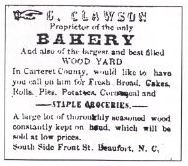 Charles and Mary Clawson first opened a general store on the south side of Front Street; they lived upstairs where Mary baked bread and pastries.
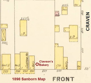
 In the late 1880s, the Clawsons bought land on the north side of Front Street, where they built a 1-story Bakery on the front part of the lot, shown on Sanborn's 1898 Map. By the 1904 Sanborn Map, a House and small Bake House (Oven) had been added; same on the 1908 Sanborn Map. By the 1913 Sanborn Map, the 2-story brick building, Clawson's Grocery and Bakery, replaced the 1-story Bakery on Front Street, and the small Bake House (Oven) had been enlarged into a 2-story brick Bake House, with 1-story oven at rear. See 1913 Sanborn images at the bottom of page.

When his father's health was failing, Charles Jr. took over the bakery business. During 1908, he began building a new 2-story Classical Revival brick store on their property (427 Front Street), replacing the bakery, just west of his parents' front yard. Shortly afterward, the bakery operation moved into a new 2-story brick building behind the new general store, enlarging the original small bake house oven (now Backstreet Pub). According to Frank Clawson, "Charles Jr. moved into his new building in 1909—Clawson's Grocery and Bakery."
Bake House from the 1997 Survey: 2-story Classical Revival building, with buff brick veneer façade, round-headed 1/1 sash, pilastered bays, stone lintels with keystones, a corbelled and dentilled cornice, and roof-line balustrade. Former Bake House circa 1908: Built in common bond brick, this front-gabled building has front and rear parapet walls. It replaced a smaller bake house.


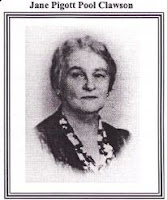 Charles Clawson Jr. (1873-1957, married Jane Pigott Pool in June 1899. Jane (1873-1951) was the daughter of James Harrell Pool and Cinderella Roberson, daughter of Malachi B. Roberson and Sarah Bell. Charles and Jane were parents of James Pool, Charles Alfred III, Marie Hinton, William Carlton, Franklin Doane, and David Pool Clawson.
 According to their son, Frank Doane Clawson, in The Researcher 1998:

“When Charles Jr. moved into the new building in 1909, Clawson’s Grocery and Bakery would become a prominent establishment, a modern grocery store, with the added service of a six-stool soda fountain. …The clerks reached items on high shelves by means of a ladder that moved back and forth on rollers. …Many of the orders for groceries and baked goods came in by telephone, and each customer coming into the store was waited on by a clerk―there was no self-service in those days. Deliveries to the residences and institutions were made by horse-drawn wagon. Goods were also sent by mailboat to the Down East communities.

“Access to the second floor was by a covered staircase. For a few years it served as a millinery shop run by Mr. Clawson’s sister Christine [who married Joseph W. Moore, son of Tyre Moore.] This level was covered with a beautiful hardwood floor. After World War I, his older children, James, Charles III and Marie turned it into a Thursday evening ballroom to be shared with friend, music coming from a hand-cranked Victrola.”
The business prospered until the Great Depression, finally closing in 1934. Thereafter, several businesses occupied the building. Sold on the courthouse steps in the 1970s, it was purchased by Candy and Bill Rogers, who opened the first Clawson's Restaurant. They operated the restaurant for 7 years, and the Hill family operated it for one.
In 1985, Fred and Joyce McCune purchased Clawson’s and the neighboring
building which housed the Fishtowne Alley shops in the old P.H. Rose 5
and Dime store.


About 1881, Charles Pittman "C.P." Dey opened a large menhaden plant at Lennoxville Point.
Charles Pittman Dey (1844‒1932), son of farmer John W. Dey and Eleanor “Emily” Pittenger, was born in New Jersey. In 1868, Charles married Almira T. Dudley in Carteret County, NC. Amira Dudley (1843‒1917) was born on Portsmouth Island, NC, to Dr. Samuel Dudley and Susan Decatur Salisbury.
The 1870 census recorded Charles and Almira, farming in Middletown, NJ, living with Charles’ parents. By the 1880 census, they were still in Middletown, Charles recorded as “Proprietor Fish Factory.” By 1900, they were renting a home on Ann Street in Beaufort; he was noted as a merchant.

 |
| Dey House at Front and Queen |
OF NOTE: Mrs. C. L. Swindell (Lorna Stanton Hales) was one of the founding members of the Beaufort Community Club (Woman's Club), as head of the "Entertaining Department."
After a long stay at the VA Hospital in Kecoughtan VA, Dr. Swindell died at 69 of bronchogenic carcinoma, and was buried at Hampton National Cemetery, Hampton, VA.
The Dey-Swindell House at 605 Front Street was demolished in 1955.
______________________________________________________________
The Beaufort News - New Dey Boats - Sept 18, 1930
"Washburn Seminary" by Principal B.D. Rowlee; The American Missionary 1902

Should one traveling by the coast line desire to see this eastern section of North Carolina, he has only to leave his train on reaching Goldsboro, secure a ticket over the Atlantic and North Carolina Railroad to Morehead City, where a launch is waiting to bring to bring him to Beaufort, one of the oldest towns along the coast. Here he will find a quiet, healthy place, where he can secure relief from tired nerves or business cares. Fish, oysters and clams will be among the articles of food set before him to tempt his appetite. If it be the right season of the year, and he be so inclined, he can venture out with gun or fishing-rod and bring back with him, as a result of his expedition, at least a good appetite.
He will find a town of about twenty-five hundred inhabitants (about equally divided between the two races) that draws its sustenance mostly from the water. The stores supply the need of the people in the immediate surroundings and also wholesale to the stores along the sound.
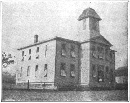
In the days of long ago the town was begun on this peninsula that cuts out into the sea. Some say that it was started by the notorious Captain Kidd. The education interests of the children are now well provided for by the schools which have been established for the races. Here the Freedman's Bureau early started a school that later passed under the care of the American Missionary Association. Since its founding it has seen days of prosperity and adversity. The past few years it has been moving forward, gaining the confidence and receiving the support of the people. While many of them are very poor, they are willing to make sacrifices to keep their children in school.
The burning of the school-building several years since led to the erection of the present one. This is two stories and contains seven rooms and a chapel. The cupola supports a staff from which, on pleasant days, flies a 12-foot flag that may be seen for miles around both from land and sea.
Besides the school-building is the shop where the boys are taught carpentry, and on an adjoining lot is the Congregational church. The home for the teachers is a very comfortable two-story building, situated in a very pleasant part of the town, about three blocks from the school.
The literary work of the school is divided into four departments, primary, intermediate, grammar and normal, with courses of study as near like those in Northern schools as circumstances will permit.
In the sewing department the girls have to begin by learning to hold the needle, wear a thimble and make straight seams. They then pass on from this, step by step, until in the higher grades they cut, baste and fit garments. All work below the normal is done by hand, the sewing-machine not being used until they reach that department. They take great delight in this work and are anxious for the sewing hour to come. Learning to sew has to them, also, a money value. They not only do their own sewing, but are able to secure work from others. On visiting at a home, one of the girls was found cutting and making a dress for a little sister. The mother acknowledged that she could not do it, but rejoiced that the girls were learning that which make them such helps in the home. Other mothers have told how much help has come to them through this department.
For the boys, the shop is one of the important departments of the school. They are here taught the use of tools, to make drawings and then to work from them. The whole aim is to makes of them self-reliant men and women, able to go out and help themselves and others.
The graduates of the school are making records for themselves. One has charge of the carpentry department of the school, some are teaching, one is in business with his father, and two are working in Yale College and attending night-school. Some of the older pupils are now in Shaw University, and one who was graduated from Livingston College is now in the public schools.
The amount of school money is so limited that in the small towns, and in the country districts, the length of the school year is only a few months.
Notwithstanding Governor Aycock's assurance that there should be no school for white or colored where there was not a four-month term, there have been schools with only two to three months' session. With so short a time given to school the progress must of necessity be slow, many even forgetting before another term opens what they learned the last. At present there is a movement on foot to consolidate the smaller districts and improve the system generally.

The passage of a law requiring an educational qualification as an essential to exercising the elective franchise has inspired some with a desire to obtain the necessary education. On the other hand, there are those who, if they give it any thought, receive no inspiration that leads them to try to rise to meet the requirements.
Numbers of the pupils take advantage of fair days and right tides to go clamming and oystering to earn money to pay tuition, buy a pair of shoes or needed clothing. It goes without saying that this retards their progress. One old grandmother goes down on the shore, gathers oysters from the rocks, opens and sells them to pay her grand-daughter's tuition. The location of the town is such as to make life too easy to develop one's energies. Many who can go down to the water and get their dinner of fish, oysters or clams are not disposed to worry much about where tomorrow's dinner is to be obtained. Again, they are not thrown into the way to brush against the world's moving throng.
The town is well supplied with churches—perhaps too many—to look after the spiritual needs of the people. All the work of the school is done with the one aim of developing Christian character. We feel that if we fail in this the great object of the school has not been accomplished. The desire is to send out young men and young women with the purpose to do something, who can, under the Spirit, meet temptations, overcome them, and train others to stand against them. The Thursday evening prayer-meetings have been the means of developing the spiritual nature in many of the pupils.
___________________________________________
From Historic Beaufort: A Unique Coastal Village Preserved:
"The founding of Beaufort's first permanent African-American school was undertaken between 1866 and 1867 by the American Missionary Association and the northern Congregational Church, probably as a result of the work of Rev. Horace James in his efforts to provide for black refugees in the town and vicinity. Located in the heart of the traditionally black neighborhood, St. Stephen's Congregational Church and Washburn Seminary were highly regarded black institutions. The story of their founding remains one of the pivotal events for Beaufort's African Americans.
"Both Washburn Seminary and St. Stephen's were in existence by 1870, when census records list preacher Edward Ball, along with several women teachers from Wisconsin and Vermont. One of the seminary's founding black trustees, Michael P. Jerkins, left Beaufort to attend Howard University's School of Religion. He was ordained in the Congregational Church in 1879 and returned to Beaufort by 1880, when he was listed as a teacher; by 1882 he was pastor of Beaufort's young Congregational Church. It was Jenkins who established the reputation of the seminary and St. Stephen's, providing the vision and background needed to give Beaufort's blacks their first school. Gray's 1880 Map shows two buildings had been erected on the lot purchased in 1867, than labeled as the 'Washburn Seminary' and the 'Colored Congregational Church' (322 Craven).
"These first structures were subsequently expanded by the ambitious construction of a large 2-story school building with a 3-story bell tower. As late as 1896 and 1897, the only school in Beaufort for blacks was Washburn Seminary, with a total of five black women teaching all of the town's black students: the Misses Mamie Fisher, Maggie Fisher, Maud Hazel, Nannie Matthewson and Mary Parker. Only the workshop remains." (Peter Sandbeck)


