"The City of Gentle Breezes" 1924

Drummond's Pictorial 
Atlas of North Carolina  
(Published 1924)

BEAUFORT
"The City of Gentle Breezes"

"Beaufort is located on the Southern shore of Carteret County about midway between the eastern and western extremities of the County. Beaufort is nearer the Atlantic Ocean than any town or city in the State of North Carolina, having 2500 or more inhabitants. Carteret County is bordered on the south and east by numerous sounds which are separated from the Atlantic Ocean by narrow reefs which form two bays on the Atlantic side--Onslow Bay on the south, and Raleigh Bay on the east. Cape Lookout on the Atlantic is just twelve miles southeast of Beaufort. Carteret is bordered on the north by Pamlico Sound, the Neuse River, Craven County and Jones County, while the White Oak River forms the western border. Beaufort, itself, is almost completely surrounded by water. It is on a peninsular jutting into the waters of Core Sound on the east, Beaufort Harbor on the south, and Newport River on the west. On the north it is bounded by one of the most fertile sections of farming lands in the whole State.

 
"Beaufort is one of the best located Ports of the State. It is nearer the Atlantic Ocean than any other city of the State of over 2500 population. It is directly opposite Beaufort Inlet, less than a mile away. Its harbor, thus sheltered, is within easy access of all ships plying along the coast. Cape Lookout lighthouse is only twelve miles south of the city. Beaufort lies in 34 degrees north latitude and 76 degrees west longitude. It is in the extreme eastern part of North Carolina, Elizabeth City and Edenton being the only two cities in North Carolina of over 2500 population located further east.

"The city of Beaufort is served by the Norfolk-Southern railway. This road runs due west from the city, across the Sound to Morehead City then turns north to New Bern, 38 miles away. The main line from Beaufort runs on through Kinston to Goldsboro. At Goldsboro direct connection is made with the Southern Railway to Raleigh, the State Capital, 146 miles from Beaufort, and to Greensboro, 227 miles away. At Goldsboro connection is also made with the Atlantic Coast Line from Wilmington to Wilson, Richmond, Washington and points North. Washington is only 379 miles from Beaufort. At New Bern connection is made to Norfolk, 208 miles away, over the Norfolk Southern Railway, and to Wilmington, 125 miles south over the New Bern-Wilmington branch of the Atlantic Coast Line. Four trains daily, two in each direction, give the city quick connection with both Northern and Southern markets. Fish and other seasonable products are exported quickly and safely to distribution points and markets.


"Naturally, a county bordering on so much water carries on a large commerce by means of boats. Beaufort has thousands of dollars invested in boats, with a number of freight, passenger and mail boats running regularly between the city and other points both far and near. Beaufort is the Southern terminal of the Boston-Beaufort Inland Waterway.

"Beaufort has just installed a sewer and water system which covers the whole town. It has paved sidewalks and is now paving the principal streets. A fine seawall lies in front of the town. The city owns her own water and electric plants. Beaufort has good public schools and a large private school. Baptist, Congregational, Methodist and Episcopal churches are here. Investigation of Beaufort's numerous advantages is welcomed by the Chamber of Commerce.
 

"State Highway No. 10 extends over 600 miles across the State from Murphy through Asheville,Hickory, Statesville, Salisbury, High Point, Greensboro, Durham, Raleigh, Goldsboro, Kinston, New Bern, and terminates at Beaufort. This is now being hardsurfaced. In addition, county roads bring all parts of the County into connection with Beaufort.

"Beaufort is the County Seat of Carteret County and is one of the oldest towns in North Carolina. Carteret County was originally a part of the precinct of Bath which was one of the divisions of territory made by the Lords Proprietors soon after assuming control of the Carolinas in 1663. In 1722 Beaufort was made a Port of Entry and was incorporated the following year by the General Assembly. 

"The present population is composed mostly of the descendants of these early settlers. The first court house was erected in 1728 and the first jail in 1736. The court house contains many interesting records of the early days of this community.

"The fishing industry in Beaufort is one of the largest in the State and furnishes employment to hundreds of people and approximately a million dollars is invested in boats, nets, factories and other equipment. The U.S. Government maintains an experimental station and laboratory on Pivers Island in the harbor.

"The lumber industry is a big one here and the largest mill in the County is located on the outskirts of the town. Besides the saw mills there is a barrel factory which supplies barrels to the potato growers and also makes fish boxes. There is also a knitting mill, an ice factory, and a canning factory in Beaufort. Opportunity is open for other factories here.

"Beaufort enjoys a remarkably pleasant climate, characterized by mildness in both winter and summer. This noted mildness is a natural result from the influences surrounding this location. It is nearer the Gulf Stream than any town in North Carolina, being only about fifty miles from this great ocean stream. Snow is a rare occurrence here and there is but little frost. Roses and flowers often bloom out of doors in January. The average winter temperature is 47.5 degrees; summer 78.4 degrees.


"The tourists who visit Beaufort in either summer or winter can always find somethings interesting to do. Trips to the ocean beaches, to Old Fort Macon, Cape Lookout, and into the back country are all of unusual interest. The sportsman can always get good fishing and in season there is good shooting. Bear, deer and foxes are fairly plentiful and there is an abundance of duck, goose and brant shooting in nearby rivers and sounds. There are several good hotels, restaurants and boarding houses which cater to tourists.
Beaufort offers excellent opportunity for the development of shipping facilities, and fishing activities. The farmer is welcomed to the rich lands of the county while the steadily increasing tourist trade offers great possibilities."

*© This work is the property of the UNC at Chapel Hill.
Click image to your left to go directly to the source. 

Drummond's Pictorial Atlas of North Carolina.

Drummond, Albert Y.,148 p. incl. front., ill.,Charlotte, N.C.,Albert Y. Drummond,Winston-Salem, N.C.,Scoggins Printing Company, Inc.,1924, Call number NCC Folio -- FC917 D79 (North Carolina Collection, University of North Carolina at Chapel Hill),"Edited and Published by Albert Y. Drummond."

Ann Street - Early 1900s


This photo was taken about 1912 on Ann Street. My friend Nancy McKee Smith’s mother, Louise Gordon Thomas, born in Beaufort in 1906, is about 8 years old. Nancy’s mother went to St. Paul’s School until 1918. The small boys are Louise's twin brothers - Thomas Thomas and Edward Gordon Thomas - born in 1910. The Thomas family lived in the second block of Front Street, referred to in a letter from Nancy's mother as “…a wide road made of oyster shell between the house and the wharves.” Click the photo and notice the "ribboned" goat hooked up to the interestingly-designed cart.

Reserve Cutter Stationed Here During Civil War

US Revenue Cutter Forward
Oil Painting-Artist Unknown
Coast Guard Academy Museum Art Collection
The Forward, a 89-foot topsail schooner that displaced 139 tons, was built by William Easby of Washington for $3,786.75. She was in service from 1842 until she was sold in 1865. She was home ported in Baltimore, MD and later Wilmington, DE and saw service during the Mexican War, including the assault on Tabasco in 1846. She was transferred briefly to the Coast Survey in 1847. During the Civil War she was stationed in Beaufort, NC.

Mailboats

Typical US Mail Boat
Prior to bridge and road construction in the eastern part of the Carteret County, mailboats were a lifeline for folks. The boats were used to deliver passengers and cargo, as well as mail to points east of Beaufort, all the way to Ocracoke Island. 

Before his appointment as postmaster at Beaufort in 1933, Wiley Higgins Taylor Sr. worked on the mailboat to Ocracoke.

At one time Matthew Marshall ran the mail boat from Beaufort. The Down East community of Marshallberg was named for him; before it became a village, it was known as "Deep Hole Point." (It is said that clay dug from the area was used to fill ramparts and cover easements at Fort Macon on Bogue Banks - leaving a large hole.)  

Kelly Willis was mail carrier for Harker's Island when the bridge was completed in 1941, when he began transporting the mail by car. Beaufort's mailboat was in service until the 1957. 

One of the murals in the Beaufort Post Office depicts Orville G, the supply and mailboat on its way to nearby Cape Lookout Lighthouse. In conveying the boat with a stormy sky and rough sea, the artist* shows the hardships incurred by the crew of the boat and by the keeper of the light.

*This and four other murals, painted in 1940 by a Russian immigrant Simka Simkhovitch, are now considered by the US Post Office and historians as a national treasure. Simkhovitch was engaged by then-postmaster Wiley Higgins Taylor Sr. and was paid $1,900 for his work. Simkovitch's fee was funded by the Fine Arts Program, a federal project that provided work for artists during the Great Depression.

A Whale of a Story

During the 1700s and 1800s, Beaufort was important in the whaling industry. Shackleford Banks was the center of whaling activities in North Carolina. Here is a little history and a whale story from By the Water’s Edge, by Joel G. Hancock, reprinted from Strengthened by the Storm, in chapter one… 

"... The largest and most distinctive of the (pre-1900) downeast communities was Diamond City. It was situated near the east end of Shackelford Banks at “the mouth of the Ditch.” By 1895, it may have had a population of as many as five hundred. Like most of the Outer Banks of North Carolina, it was first settled in the early part of the eighteenth century. 

"The community had its most rapid growth in the 1850s, spurred by a boom in the local whaling industry. New England whaling vessels are known to have visited the area as early as 1726. Local shore-based whaling crews eventually supplanted the Yankee whalers and by 1880, six crews of eighteen men each were working off Diamond City's beaches. Whaling was seasonal and limited almost entirely to the months of February, March, and April.

"To the people of Diamond City and Shackelford Banks, matters of the spirit could be just as real as the more tangible aspects of life. Indicative of such is a story told of William (Billie) Hancock by his grandson and of how a vivid dream on a late spring evening helped to save Diamond City from a summer of privation.
 
"According to the story, the spring whaling season of one year in the 1870s had passed without the sighting of a single whale. Finally, in mid-June, a whale was spotted far off the Beaufort Inlet and Billie Hancock's crew set out to bring it in. 
 
"They floated the boat out until they put a lance into the whale. They started shooting it, but the whale was so big that shooting it didn't do any good. The moon was shining bright, so they hung with the whale until after the night had fallen. Then the whale headed out toward Cape Shoals. The line on the whale finally broke and they lost it. Everybody was so worn out that they rowed back to shore very discouraged. 
 
"They were so tired when they got home that my grandfather went right to sleep and had a dream. His dream was so real that he got out of bed and went and called two more men from the crew and told them what he had dreamed. He had dreamed that the whale had died and had grounded at Cape Point. After telling the others, he began to run to the Point (approximately six miles) to see for himself if the whale had, in fact, washed ashore. The other crewmen must have accepted what their Captain had told them for they soon followed him to the Point.

"Grandfather ran straight along down the beach because there were so many trees back then. He said that when he got to Cape Point the tide was so low and the moon was shining so bright that he could see something out on the reef. He said to himself, 'That's got to be that whale! We need it so bad!' So he waded off and soon saw that it was the whale.
 
"Now came the big problem. On high tide the water would get so high that the whale would float off the Point and they would lose it. He thought that if only he had enough rope to run off and tie it to the whale they then would be able to hold onto it even after the tide came in. Fortunately, his crew had followed him and together they were able to save the whale from drifting off . . . I don't remember what they got for the bones, but they got forty barrels of oil and they made $40.00 a share. I was told that after it was all over they came back to
Diamond City and had a big square dance."
__________________________
 
Diamond City was just off the coast of Beaufort until the late 1800s when a coastal storm swept away it's large dune and caused residents to build make-shift barges and relocate their houses to Harker's Island, Morehead City and Salter Path.

Samuel Leffers 1736-1822

Samuel Leffers spent 58 Years in Beaufort as schoolmaster, surveyor, Clerk of Court, merchant and planter. He left his signature for generations to come.

Leffers was born November 7, 1736 in Hempstead, New York. Most family trees believe Samuel to be the son of Leffert Haugewout (1712-1795) and Mary Smith (1712-1742), whose ancestors came from the Netherlands. 

Leffers came to Beaufort in 1764, at age 28, as the “sober and discreet qualified man” recruited to teach at the Beaufort school. He married Sarah Hampton (1739-1808) November 30, 1766 in Straits, Carteret County, NC. Sarah was the daughter of Beaufort cornwainer (shoemaker) Thomas Hampton.
 
In James Winwright's 1744 Will, he made provisions for "the building and finishing of a creditable house for a school & dwelling house...to be erected and built on some part of my land near the White House..." Leffers most likely lived on this property near the White House when it came to town in 1764. (At the time there were only a handful of houses in Beaufort.) What was his "dwelling house" may have been destroyed by fire when the British burned the schoolhouse in 1782.  

"Leffers Cottage"

Leffers purchased lot 12 New Town (southwest corner of Front and Live Oak streets) September 13, 1775 from town commissioner for 30 shillings proclamation money; a provision in the deed required Leffers build a house within two years or the deed would become null. (deed bk 1, pg 159) On September 12, 1776, Leffers sold this lot including a "singular premises" to Daniel Guthrie for £3 proclamation money. (deed bk I, pg 251):

To all people to whom these Presents shall come Greeting. Know ye that I Samuel Leffers of Carteret County in the province of North Carolina schoolmaster for and in consideration of the sum of three pounds proclamation money to me in hand paid by Daniel Guthrie of the place aforesd. The receipt whereof I do hereby acknowledge. Do hereby grant bargain sell convey and confirm unto the said Daniel Guthrie his heirs and afsigns forever one certain lott or half acre of land situate in Beaufort town in the County aforesd which lot is known and distinguished in the plan of the said town by the No.12. of the New Town, and was granted to me the said Saml Leffers by the Commissioners of the said town by a deed bearing date, the 13th September 1775. it being the original entry. To have and to hold the said lot or half acre of land, together with all and singular the premises, and privileges...in witness hereof I the said Samuel Leffers have hereunto set my hand and seal this twelfth day of September, One thousand seven hundred and seventy six. This deed was registered/proven in the June 1778 court.

What has been designated as the Samuel Leffers Cottage circa 1778 was donated by Leffers' descendants and moved to the Beaufort Restoration Grounds in 1983. 
 
 Leffers Cottage - 146 Turner Street
 
However, an analysis of the fabric of the house, by the Architectural Research Department of the Colonial Williamsburg Foundation, 2012 Field Study in Beaufort, revealed a building date of 1840-1850, some two or three decades after the 1822 death of Samuel Leffers:

The Leffers House is a one-and-a-half story small frame house with a later shed addition. Originally located on the corner of Live Oak and Front Streets, the house was moved to this site on Turner Street in the 1980s and restored and open to the public by the Beaufort Historical Society. The dwelling is said to have been built about 1778 by Samuel Leffers who was a school master in late colonial Beaufort and later became a surveyor, clerk of court, merchant, and planter. He died in 1822 at the age of 86. Unfortunately, this is not the house that Leffers built and lived in. Rather it was built perhaps two to three decades after his death in the late antebellum period.

Originally, the house consisted only of the front portion, which measured a little over 21 feet in width and 17 feet deep with a habitable half-story above stairs. The original plan consisted of a central doorway flanked by two windows on the front façade, which led into a large heated room measuring 13 feet in width and 16 feet in depth. The exterior chimney was located in the center of the gable end (the present brick chimney is a modern replacement). A doorway into a smaller unheated room opens opposite the fireplace. This space is less than seven feet in width. The stair to the half story originally opened in the main room in back corner of this partition wall between the rooms. It was a winder staircase that turned and ran back along partition wall to unheated spaces upstairs.

Sometime in the late nineteenth century, a ten-foot deep shed was constructed across the backside of the house. Originally it was divided into two rooms, the back door of the main house opening into the larger of the two unheated rooms. At that time, the original staircase was reworked so to run in a straight flight from the back shed room to the garret above. The old doorway from the main room in the front was blocked with circular sawn lath and plastered over. All the framing of the shed consists of circular sawn timbers.

_________________________________
     In 1795, Samuel Leffers purchased the 25-acre "White House" property, including the house, windmill and other improvements, from Elias Albertson Jr. for 350 Spanish dollars. That same year, Leffers advertised the windmill for sale. Over the next few years he added to the property by purchasing adjoining acreage. 

"Hammock House" - early 1900s
      In an October 19, 1800 letter to his brother John Lefferts in Long Island, New York, Samuel Leffers wrote: 
 
"My situation at present is agreeable, my new house is calculated to my fancy and pleasantly situated, we have a fine prospect of the Sea, in front have a good garden and spring of water and are about 200 yards from the eastern most boundary of Beaufort town.
 
    Leffers' new house, known today as the "Hammock House" was built about 300 yards east of the "White House," which was 100 yards west of the town boundary, the boundary described as "100 yards to the eastward of the hammock that Thomas Austin formerly lived on."
(Detailed research contained in Historic Beaufort, North Carolina.)


Painting by Mary Warshaw
Leffers sold his 42 acres on Taylor's Creek, including the "Hammock House," to Henry Marchant Cooke for $1,300. He boarded with Cooke for about a year until he moved to Straits to live with his son Samuel. In 1820 he purchased his own house in Straits.

Below are some interesting snippets from Leffers’ letters to his brother John– written between 1800 and 1821:
……1800 My situation at present is agreeable, my new house is calculated to my fancy and pleasantly situated; we have a fine prospect of the Sea, in front have a good garden and spring of water...I live retired and amuse myself with my garden, my writing desk, my books and a walk to town as fancy directs……
……Our Vessels which use the West Indies trade having for a long time past accustomed to make good voyages and bring home considerable quantities of cash bring nothing of late from the English Islands but rum……
……the coming storm…The rising wind and falling rain ushered in the morning…… the violence of which progressively increased…… it raged with a violence which I cannot well describe. Fruit trees of every description are either torn up by the roots or left naked……
…… we took a fine sea turtle which was very seasonable, had fine weather to dress a part of it which made us a most delicious repast……
…… The crops of corn are supposed in general to be better than ever was known and every other production of the earth uncommonly good…I have sent Samuel with his uncle Thomas Duncan, to assist in doing my business……
…… I wrote my own Epitaph some years ago (1806), and altho` it may never be engraved on stone you may read it for your amusement as follows:

PRAISES ON TOMBS ARE VAINLY SPENT 
GOOD DEEDS ARE MANS BEST MONUMENT 

…… April-1809 Government have had a Fort [Hampton] erected here, the work has been going on for 6 months past…The winter has been cold and stormy but tolerably healthy- provisions are plenty and cheap- and every housewife is busily employed in clothing her family in homespun and altho` goods are scarce the prices are low and the sale dull……
…… My little family continues as before with the addition of George Dill who lives with us and serves to run errands and do little jobs about house……
……1811 The alarm of war is amongst us and a Battalion of the new raised Militia are to be posted here and at Fort Hampton which is at the Inlet point opposite the Town……
……1814 When I wrote you last I was a boarder in the house that I formerly owned where I continued till about 20 months ago, when as Samuel had taken a house in a pleasant situation on the waters of the Straits, I agreed to live with him……
…… 1815 I am within a few weeks of finishing my 79th year and altho` I am blessed with a good degree of health the infirmities of age are daily reducing my strength and I can perceive my mental powers also are fast declining there fore you need not be at a loss to account for the imperfections of my letter……
……1820 After I recovered from my sickness and found I had still to live I thought it might be most for my comfort to have a home of my own in a retired situation to spend the remainder of my days without being beholden to others. I therefore purchased a house and small farm at the Straits……
…… Aug.1821 I enjoy tranquility of mind and being at peace with the whole world I wish well to all the human race... I have made my will……
……Nov. 1821 I am alternately stronger and weaker at short intervals I can plainly perceive that I (am) gently descending from my present stage of life……

Leffers died a year later on October 7, 1822, about one month short of his 86th birthday. He was buried in Beaufort's Old Burying Ground.

The children Samuel Leffers and Sarah Hampton (1739-1808), as noted in family trees and in Maurice Davis' History of the Hammock  House:
  1. George (1767-1793) married Hannah Gibble about 1791 and was lost at sea. "They had only one son, Samuel II (1792-1875), who studied medicine under Dr. John Poythress, who had a private infirmary in Beaufort before his death in 1813. In 1811, Samuel II married Sarah Brooks of Straits, where he established his practice. Richard (1832-1912), the youngest of their seven children, also became a physician and practiced at Straits for many years." 
  2. Asa (1769-), "the second child of Samuel and Sarah, also married a girl named Hannah and also died at sea." (Davis)
  3. Susanna (1771-1808) first married Isaac Hellen in 1787. After Isaac's death, she married William Thomas.
  4. Mary Ann (1773-1816) married John Dill in 1793. 
  5. Sarah "Sally" (1776-1850) married Williams Brooks in 1811. 

1900 St. Paul's School & 1905 Watson Hall Teacherage


1898 Sanborn Map
The first St. Paul's School opened in 1858. With about 30 pupils, the school was led by Rev. Van Antwerp, with teachers Caroline Van Antwerp, Elizabeth Roberson and Sarah Pasteur, the school closed in 1867. In 1899, the school reopened under the guidance from Rev. Thomas P. Noe, with help from Sarah Pasteur's daughter Nannie P. Geffroy. The school operated in a small building, first mapped by Sanborn in 1898. After the new school was built in 1900, facing Ann Street, the old building became the "Manual Training School."

In 1885, bookkeeper Malachi Roberson Geffroy (1861-1938) married Nannie Pasteur Davis (1865-1936), daughter of Sarah Pasteur and James Chadwick Davis. Born Mary Ann Davis, she changed her name to Nannie Pasteur Davis sometime before her marriage to Malachi. From 1899 until her death in 1936, 201 Ann Street was second home to Nannie Geffroy, first as secretary-treasurer, then headmistress of St. Paul's School. The school operated until Mrs. Geffroy's death in 1936. 

In 1900 a new school (above) was erected on the lot east of the church, followed in 1906 by Watson Hall dormitory (below) between the church and 201 Ann Street. (The small school building, was then used as a Manual Training School.) These two images were taken from the 1909-10 St. Paul's School Catalogue.


Watson Hall dormitory building was built in 1906. 
The structure was named for Alfred A. Watson, former bishop of the Diocese of East Carolina.

Mrs. Geffroy and Staff circa 1910

In the mid-1940s, part of Watson Hall Dormitory was saved from demolition, moved to 209 Orange Street and converted to a private residence, home to James Noe, a Midgett family and others. 

The unique, stacked corner front porches of the Orange Street "teacherage" once faced the back courtyard of St. Paul's School and overlooked what is now the newer part of the St. Paul's Episcopal Church Cemetery. The structure functioned partly as lodging for the teaching staff. 

The retained multiple front doors of the home once provided entry to small classrooms on what is now the right front of the house—one up, one down. Historical evidence is still visible on the upstairs level, marking where a separating wall once existed. Scorch marks on the classroom floors remain where the wood-burning stoves once served for warmth. The structure also functioned partly as lodging for teaching staff—hence the name Watson-Hall Teacherage.

In 1960 George Huntley III, a Beaufort High School senior, wrote an article in Echoes of the Past, titled “Nannie Geffroy Revived, Developed St. Paul’s School.” “The dormitory building rooms,” he noted, “were equipped with white enameled beds, chiffoniers, and wardrobes, while the sanitary washstands with running water added to the comfort.
The building was equipped with adequate bathrooms with hot and cold water and lighted throughout with electricity.” Some local residents still recall their childhood association with St. Paul’s School with imagined or real memories of what once occurred inside the walls of this historic building. One recalled watching, as a kindergartner, her teacher step out the door of the classroom, onto the porch to talk to her “beau.” 
______________________________________________________
Heritage of Carteret County Vol. 1 - Jan. 1982

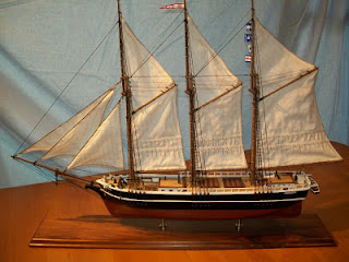
"Crissie Wright"

http://beaufortartist.blogspot.com/2009/09/model-of-crissie-wright.html
JIM GOODWIN MODEL
On January 7, 1886, the Philadelphia schooner Crissie Wright, on her way from Baltimore to Savannah, was forced to beach herself three miles east of Beaufort during the bitter winter of 1886. Six of the crew drowned and froze to death. Two of the crew were lost at sea and three were buried in a common grave in Beaufort’s Old Burying Ground.

 In The Story of the Methodist in the Port of Beaufort, 1941, Amy Muse wrote,

“…..that winter so cold that no one remembered its like before or has acknowledged its equal since. The winter when the Crissie Wright foundered on Shackelford Banks, the crew lashed to the rigging and freezing while men who would rescue them could only signal helplessly from our shore unable to put out a boat in the storm.

"The Nellie B. Dey, Mr. Dey's fish boat, finally brought the victims in to the wharf at the foot of Turner Street. But one man was revived; the others were laid out in the sample room of Mr. Billy Dill's hotel on the southwest corner of Front and Turner Streets and Mr. Jurney buried them in the graveyard back of the Church.

“'Miss Daisy' Hatsell tells of standing in the cold of the upper piazza of her home on Queen Street watching as the men were borne to the cemetery on improvised biers, and “Miss Lutie” Jones tells of the feeling of awe that came over her when as a child she ran in to the cemetery and saw so many graves open at the same time. None of the men were from Beaufort, but it was an incident that would have stirred any people and to a people as compassionate by nature as those in Beaufort, it left such an impression that voices are hushed to-day as the story is retold. A small compensation for the tragedy was the establishment of the Cape Lookout Life-Saving Station in 1887 which is said to have been a direct result of the event.”

 _______________________

On Saturday, May 26, 2007, the following article was published 
in The Courier Post, Cherry Hill, New Jersey:

"Only One Survived Sinking of Jersey-built Schooner in 1886"

The coast off North Carolina is called the Graveyard of the Atlantic, thanks to thousands of ships and lives lost to the sea during the past 300 years. One of those ships, the schooner Crissie Wright, was lost to the sea in January 1886. It had its roots in South Jersey.

The "New Jersey Patriot" newspaper of Bridgeton reported in its Jan. 16, 1874, edition that a fine three-mast schooner was being built at the Blew and Phillips shipyard in Bridgeton.

The Crissie Wright was launched July 11, 1874, according to the "New Jersey Patriot," which described the schooner as a staunch and graceful vessel.
My interest in the fate and history of the Crissie Wright is personal, coming from an entry in our family Bible that lists the death of my Great Grandfather Phillip H. Rickards on Jan. 10, 1886. He froze to death aboard the Crissie Wright, along with five other crew members, including Capt. Thomas P. Clark of Berlin, buried in the Berlin Cemetery.

The Crissie Wright set sail from Baltimore on Dec. 31, 1885, with 500 tons of phosphate headed for Savannah, Ga. After making her way through the Chesapeake Bay, the ship entered the open waters of the Atlantic Ocean. On or about Jan. 7, the Crissie Wright was off the coast of North Carolina when a winter squall turned into a violent storm.

Treacherous Weather

Capt. Clark decided not to risk the Diamond Shoals in the threatening weather -- high winds and a drastic drop in temperature. Capt. Clark ordered the ship to head for a safe harbor in Beaufort, N.C. But when gale-like winds caused the main mast brace to part, Capt. Clark was compelled to beach the vessel about 6 miles west of Cape Lookout Light and 3 miles east of Beaufort Bar.

One sailor drowned in an attempt to get to shore, and another was knocked overboard and lost by the breaking of the mizzenmast. Days later, a body was found with a rope tied around his waist, with both hands missing, and his head scalped.

The Crissie Wright -- helpless on the west end of Shackleford Banks, where it lay broadside -- was breached by every incoming icy wave. Howling winds and snow and sleet covered the rigging and deck with ice, making footing most treacherous.

The crew of the Crissie Wright was without food or heat for three days and was unable to reach the mainland. They wrapped themselves in the main sail in an attempt to ward off the freezing gales.

Rescuers Thwarted

The residents of nearby Diamond City, whalers and fishermen, gathered on the beach and built large fires to signal crew members they knew of their plight. In an attempt to rescue the crew, residents carried and dragged their boats over the dunes and tried repeatedly to launch their small boats. But the force of the storm and power of the incoming waves repelled each attempt. Horrified residents stood helpless when they witnessed two of the crew going overboard.

From a newspaper clipping saved in our family Bible is a telegraph from Morehead City dated Jan. 11, 1886, stating: "ONLY ONE SURVIVOR Six of Crew of Crissie Wright Drowned or Frozen To Death. The steamer Nellie B. Dey of Beaufort, reached her today, and Captain Dudley boarded her and brought off the bodies of the four frozen men. The sole survivor is named Charles Tayt of Buffalo. Although badly frost-bitten, is expected to survive. He related how, in an attempt to keep his shipmates awake, he continuously kicked and beat them, but one by one fell into eternal sleep." CLICK TO ENLARGE IMAGES.


 A Common Grave

The frozen bodies were taken to Beaufort, and three shipmates were interred in a common grave in the Old Burying Grounds in Historic Beaufort. Capt. Clark's body was returned home to Berlin. He is buried in Berlin Cemetery.

To this day, the wreck of the Crissie Wright has remained part of the legend and folklore of the town of Beaufort. The grave of the sailors is part of the historical tour of the Old Burying Grounds.

A MURAL in the Beaufort Post Office by Russian painter Simka Simkovich depicts the townspeople's attempt to rescue the stranded seamen. Numerous stories have been written, often taking liberties with the facts. A poem by Benji Taylor, "Life on the Banks," tells the story of the wreck. 


Of the thousands of ships that have gone down off the coast, the Crissie Wright captured the imagination and hearts of the folks of Beaufort.

"Cold as the night the Crissie Wright came ashore" was a way natives of Beaufort once described extreme cold weather. It is said this tragedy led to the establishment of the Cape Lookout Lifesaving Station in 1887.

More Information Sought

In an attempt to uncover as much related history of the Crissie Wright as I could, I contacted the N.C. Underwater Archaeology Department, which forwarded all the information on file, including a copy of the official accident report.

The ship was valued at $20,000, and cargo was valued at $30,000 -- all a total loss, the report says. Capt. Thomas P. Clark, master of the vessel, was the only crew member named.

Dave Moore, curator of nautical archaeology at the North Carolina Maritime Museum in Beaufort, says there are tentative plans to search for the remains of the Crissie Wright.

The name of the ship apparently came from the family of one of the investors.

While Capt. Clark was the principal owner, other investors were Bartlet and Shepherd, Jacob E. Ridgeway, M.A. Davis and Charles Wright.

In the "History of Berlin," Charles Wright is listed as a businessman, and his wife and daughter are both named Christine. Capt. Clark, a widower, was survived by his 15-year-old daughter, Sallie. Ironically, Charles Wright's son Walter Wright married Clark's daughter Sallie. Christine Wright -- "Crissie" -- became Sallie's mother-in-law.

My Great Grandfather Phillip H. Rickards was born in Cedar Neck, Del., in 1835, one of nine sons of Capt. Lemuel W Rickards, from a family of mariners. His body lies in a common grave with his mates at the Old Burying Grounds in Beaufort. I plan a visit to the gravesite to pay homage to his memory.
C.G. "Rick" Rickards

YE OLD INLET INN - Beaufort, North Carolina
This photograph was taken in 1933 by Rick Rickards' grandfather when he visited his father's (Phillip Rickards) Crissie Wright mass-grave site at the Old Burying Ground. Rick's grandmother is sitting on the steps. Below is an advertisement most likely picked up by Rick's grandfather.


Photos provided by C.G. "Rick" Rickards

 
NEWS