Farnifold Green - Owner of First Land Patent

Part of an 18th century map of eastern North Carolina showing the "Whitehouse" on the outskirts of Beaufort. High on a "hummock," the "Whitehouse" evidently served as a landmark to help guide early sailing vessels. The "Whitehouse" may have been built as an outpost by Farnifold Green, who had the first land patent between North and Core (Newport) Rivers.

Farnifold Green was born on May 30, 1674 in St. Stephen's Parish, Northumberland County, Virginia. Records list Farnifold Green as coming to North Carolina with the Nicholas Tyler family in July of 1697. Farnifold married soon after he arrived. He and his wife Hannah Kent Smithwick, widow of John Smithwick, appear frequently among the early land records of then Bath County (later Beaufort County).
 
Map showing "Green's Land"
Green had a 1700-acre plantation (Green's Neck) on the north side of the Neuse River, but was evidently active in various enterprising pursuits, including raising cattle on the Outer Banks near Ocracoke Inlet. What is interesting is the fact that the above 1676 map shows an area noted as "Greens Land" - some 20 years before Farnifold Green supposedly arrived in North Carolina and had a plantation in this same area. It appears that the Virginia Assembly granted land along the Roanoke and Chowan Rivers to Farnifold's grandfather, Roger Green, in July of 1653. Roger Green has been born in Norfolk, England about 1620. His son Timothy, born about 1650, was Farnifold's father. 

On December 20, 1707, Farnifold Green was the first to be issued a land grant from the Lords Proprietors for land that included 780 acres—part of that land that would eventually become early Beaufort. Even though Green lived north of the Neuse River, he must have been aware that the barrier islands and cape, surrounding this land grant, had been providing a safe haven for ships and realized the possibilities for his land becoming not only a town, but a port.

About the same time, Peter Worden of Pamlico River was granted a patent for 640 acres on the west side of North River, which overlapped Green’s patent. In their settlement, documents referred to a point of land called “Newport Town” which gives evidence that there may have been a few settlers between the rivers and in the Core Sound area. John Shackelford, who witnessed this agreement, had land on a barrier island and was perhaps involved in whaling - on what would be known later as Shackelford Banks.

Living on his plantation near Oriental, Green was named to the Provincial Assembly in 1709. In 1711, he requested help in defending the colonists from the hostile Indians. He was appointed by the Assembly to oversee troops that had been assigned to put down the Tuscarora outbreak.

Obviously aware of the dangers of the times, Farnifold Green made out his will on October 26,1711. The will referred to his home near Piney Point on Lower Broad Creek. 

Farnifold Green was executor of Lewis Johnson's (1677-1711) will; Johnson left his sons William and Richard in Green's care.

On July 18, 1713, Green endorsed, to Robert Turner, all of the 780-acre tract he had patented in Core Sound in 1707. Craven Will Books, A, 10-11. (Charles L. Paul, Colonial Beaufort)

In 1714, Indians attacked Green’s Creek plantation, north of Neuse River, killing 40-year old Farnifold Green, one of his sons, a white servant and two African Americans. The plantation, house, stock of cattle and hogs, were plundered and entirely destroyed by the Indians.

Green’s widow, Hannah, later married her third husband, surveyor Richard Graves, who was hired by Robert Turner to create the town plat of Beaufort.

History of the Beaufort Town Seal and Flag

In the 1960s, the Beaufort Woman's Club, under the guidance of its president and staunch preservationist Miss Emily Loftin, initiated the development of the Beaufort town seal. 

Permission was sought from the College of Arms for adopting the Duke of Beaufort's crest for the design, but it was determined that the Duke's crest could only be used if modified. This modification included changing the lower two quadrants of the crest, replacing the Fleurs de Lis with three red roses of Lancaster - the ruling house at the time Beaufort was chartered - and substituting three fish for the lions. Once the artwork was completed, Rep. N. W. Taylor presented the seal for authorization by the North Carolina General Assembly, with final official approval by Beaufort Mayor William H. Potter and Town Commissioners Osborne Davis, David Farrior, Frank Langdale, Earl Mades and Glenn Willis in 1968. 

The Beaufort town seal was designed by Will Hon who was coordinator for educational programs in the marine sciences for the Carteret County establishment of the Aquarium. The town seal's artwork was done by Richard Thomas. It should be noted that the background color of the original design has been changed to the gold now shown on the seal and flag.

Purchase Beaufort Flag

Stede Bonnet - The Gentleman Pirate

Excerpt from The Age of Pirates

Much has been written locally about Edward “Blackbeard” Teach and his Queen Anne’s Revenge, but less regarding Stede Bonnet—a fellow pirate. All accounts and stories target Beaufort and the protected area of Cape Lookout as one of their favorite places of respite.

Unusual, unlikely and unprepared best describe Stede Bonnet, who was an educated, affluent and respected plantation owner until he decided to become a pirate.

Major Bonnet, as he was known for his affiliation with the island militia, was a wealthy sugar plantation owner from a respected English family. He lived in Bridgetown, Barbados, where he mingled with the island’s elite. In 1717, in his middle age, he abruptly abandoned his comfortable life for a career as a pirate. It was a career in which he had no experience. His decision scandalized the polite society of Barbados and Bonnet’s acquaintances thought him emotionally disturbed. Others speculated he turned to piracy to escape his nagging wife. 

Rather than stealing or capturing a ship, Bonnet bought one—something unheard of for a pirate. The ship had a single gun deck with 10 pieces of artillery. Bonnet named it Revenge. Bonnet recruited his gang from local taverns and organized a band of about 70 men. Rather than drawing up a contract for the men to sign, as was customary, Bonnet paid his crew a salary from his own pocket. This, too, was unusual for a pirate, but it helped him retain command over his men.

Bonnet kept his ship in the harbor for several days before leaving one night with no word to his family. Though inexperienced, he was moderately successful, taking ships off the coasts of Virginia and Carolina. He merely plundered the first few ships, but after burning one, Turbes, he burned every one he took. By this time his men realized his inexperience and hostility began to brew.
While anchored at the Bay of Honduras or possibly while he cruised the Carolinas, Bonnet met Edward “Blackbeard” Teach. Teach invited Bonnet onto his ship, Queen Anne’s Revenge, and then took Bonnet’s ship. Bonnet was essentially a prisoner on Teach’s ship, although, by some accounts, he contentedly spent his time there reading and walking the decks.

After being pardoned and getting his ship back, Bonnet set sail for St. Thomas—armed with a letter of marque to capture Spanish ships. To disguise himself, he renamed his ship Royal James, and took on the name of Capt. Thomas. While en route to the islands he was rumored to have gone searching for Blackbeard but didn’t find him and returned to piracy—again faring well.  

Bonnet was eventually captured by Col. William Rhett who had been sent after pirates operating near Charleston. Bonnet escaped but was recaptured and brought to trial in a Court of Vice-Admiralty in Charleston. Despite a moving letter he reportedly wrote begging the governor for clemency, Bonnet, along with 29 of his men, was sentenced to death by hanging. During his sentencing, Judge Trot was said to have made a great speech, reporting that Bonnet had killed no less than 18 men sent to capture him, and that was no way for a “man of letters,” to behave.  

Nicknamed “The Gentleman Pirate,” Bonnet’s education hurt him in the end. He was hanged for piracy on December 10, 1718 and his body was left hanging for four days as a warning to other pirates.”

The Periauger

The Periauger - a long-lost Colonial boat - was constructed in Beaufort at the North Carolina Maritime Museum by The Periauger Project. The project was a unique partnership of the Perquimans County Restoration Association (the parent organization of the historic 1730 Newbold-White House in Hertford, NC), the North Carolina Maritime Museum, Perquimans County and East Carolina University’s Program in Maritime Studies. The project was made possible by a successful private fundraising campaign and through a grant from the NC Department of Transportation’s Enhancement Program. 

Periauger is a generic term for a two-masted boat made of a dugout and split cypress log and propelled by both oars and sails. Historical references indicate that for many Colonial settlers, the periauger was the vessel of choice, especially on the sounds and rivers of North Carolina. They were shallow draft, stable, cargo-carry craft, ideally suited to the shallow sounds, rivers and creeks of Eastern North Carolina—the waterway “pick-up” trucks of those days. Periaugers were originally designed to carry many barrels and/or sacks of corn, wheat & rice, bricks, rum, etc., or to be fitted out for military duty. Benedict Arnold reported having one in his Revolutionary War fleet. 

No physical evidence of this typical Colonial vessels existed. But, after years of research and study, documentary evidence enabled plans to be drawn up for the unique 21st century reconstruction of a “typical” periauger. Supervising the design was Michael Alford, former curator of maritime research at the North Carolina Maritime Museum and author of Traditional Workboats of North Carolina. 

Periauger in Progress at a Wooden Boat Show in Beaufort
Alford designed the Periauger, using historical records and his understanding of materials and construction techniques of the day. He designed a vessel, approximately 30 feet long with two masts reaching the height of nearly 25 feet—with rowing stations for at least 6 oars (sweeps)—basically a hollowed-out Cypress tree log, split in half with a plank keel added between the two halves.

In November 2003, hull construction began in Beaufort at the North Carolina Maritime Museum's Watercraft Center,with boat builder Craig Wright overseeing the construction. At that time Wright had been responsible for building 23 boats and canoes. Sweeps and masts were previously made by a team of volunteers in Hertford, NC.
Some of the Periauger Team: (left to right): Brent Creelman of the Friends of the NC Maritime Museum; Monty Spindler, Perquimans County Restoration Association Board of Directors; Michael Alford, designer of Periauger: and Ted Huffman and Don Johnson, Periauger Project committee members.


After the interior fitting out were complete, rowing trials began for this unique vessel. There are eight rowing stations, each equipped with a 12-foot long sweep. It took a little practice to handle them, and a little more practice to handle all eight in unison. 

In the summer of 2004, propelled by its two sails, the Periauger sailed from Beaufort to its home port of Hertford in what was called The Periauger Odyssey - a three week voyage. The Town of Hertford will be the Periauger’s interim homeport until it is relocated to the historic 1730 Newbold-White House where it will be a key component to the site’s maritime heritage program. It is anticipated that the Periauger will be an important tool for regional tourism development, visiting port towns in the region and providing a dynamic living maritime history experience. 

The replica Periauger is the only known boat of its kind in the world.

Newbold-White House

The above information was compiled from
Discover Perquimans and The Periauger Project

Confederate Memorial Monument

Monument Photo by Jason Gibbs

In Memories of a Lifetime, Neal Willis noted his impression of the first time he saw the Confederate Memorial Monument. The year was 1926. Neal and his classmates were outside during recess at the Beaufort Graded School—then next to the Courthouse in Beaufort.

Neal Willis wrote, "We saw the train come in and stop in front of the Town Hall (now the site of the Health Department). We thought this odd because we had never seen it stop there before. We watched as a large wooden crate was unloaded and placed on the curb. After the train moved on we rushed over to see what was in the box. We peeked inside and saw the biggest man we had ever seen. He was a giant and was greenish in color. We didn’t linger long enough to investigate."

Willis continued, "I remember the 10th of May when it was unveiled. This date was an annual get together of school kids to hold Maypole dances and running and jumping contests. It was a country shindig with people coming from all over the county. On the day of the unveiling, Senator Simmons from New Bern, as well as other dignitaries made speeches about the Civil War. Bands played and everyone cheered as the cord was pulled to release the white sheet that covered the statue. After the ceremony, everyone went over to the cemetery to place flags on veteran’s graves. It was a very emotional occasion enjoyed by a lot of people, many of whom were descendants of veterans."

In the introduction to Mary Warshaw's book, Historic Beaufort, North Carolina, Francis Borden Mace wrote: "In 1927, at seven years old, I witnessed Grandpa Nathan Lafayette Carrow laid out in a casket in his resplendent Confederate uniform. Of their three daughters, Mother had worked with the Daughters of the Confederacy to plan the memorial on courthouse square for our boys in grey."

1997 Survey: The memorial is a 6' 6" tall bronze statue of a Confederate soldier in full uniform standing at rest, holding his gun in front. The statue sits on a stepped granite base with pedestal on the front lawn of the Carteret County Courthouse Square. Above the inscription is a stylized "CSA." The inscription reads, "Our Confederate Heroes | To the memory of the Confederate dead of Carteret County, 1861‒1865, erected by the Daughters of the Confederacy, Fort Macon Chapter, Beaufort, NC, 1926, Not even time can destroy heroism." (Tony P. Wrenn)

Otway Burns

Otway Burns was born about 1785 in Swansboro, NC. He married Joanna Grant (-1814) on July 6, 1809. On December 4, 1814, he married Jane Hall. At the age of 57, he married Jane Smith on February 22, 1842 and moved to Portsmouth, NC, where he died on October 25,1850.
________________________________________

In A Brief Biographical Sketch of the Life and Exploits of Captain Otway Burns Jr., Tucker R. Littleton wrote:

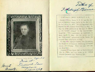
"Captain Otway Burns was born on the west side of the mouth of Queen's Creek (near Swansboro, NC). The son of Otway, Sr., and Lisanah Burns, he evidently took to the sea at an early age and soon earned the reputation of a most skillful navigator. Like his father and his grandfather before him, Otway, Jr., was deeply involved in maritime activity at Swansboro. In 1809 Burns married Joanna Grant, daughter of Colonel Reuben Grant, a Swansboro merchant. Owen Burns, the only child of Capt. Otway Burns, was born to this union in 1810, the same year that Burns bought lot number 6 in Swansboro.

"At the time that Burns bought the lot, it contained a dwelling house on the portion lying between Front and Water streets, and Capt. Burns and his young wife may have resided for a time on that lot. The lower portion of the lot, lying between Front Street and the river shore, was subsequently used by Burns for a shipyard. His wife, Joanna, however, had died in 1814, and in 1819 Burns sold his Swansboro lot to William Pugh Ferrand.

"It was his role in the War of 1812 that won Burns his fame and made him Onslow County's most famous native son and the most important figure ever associated with the maritime history of Swansboro. Prior to the War of 1812, Burns was a sailing master operating out of Swansboro, Beaufort, and New Bern, and plying the coast-wise trade with such northern ports as Baltimore, Philadelphia, New York, Boston, and Portland. When the War of 1812 broke out, Burns came to the aid of his country by operating a privateer vessel to prey on British ships and commerce.

SNAP DRAGON 
Model by Jim Goodwin
"In partnership with Col. Edward Pasteur and other owners of the SNAP DRAGON, most of whom were of New Bern, Burns carried the privateer schooner on three of the most successful voyages ever made by an American privateer. His extraordinary bravery, ingenuity, skill, and heroic exploits made Captain Otway Burns a legend in his own time and North Carolina's most famous naval hero of the War of 1812. Throughout the war the United States had only a token and woefully ineffective navy. The country was forced to rely on the help of private-armed vessels like SNAP DRAGON, whose entrance into the war was applauded as a great act of patriotism. When our "Second War of Independence" was over, Burns had captured not only a staggering number of enemy vessels and valuable cargoes but had captured the esteem and admiration of his fellow countrymen.

"Following the war, the enterprising Captain Burns returned to his old trade of shipbuilding and eventually at Beaufort tried his hand at storekeeping, salt making, brick making, and investing in the Clubfoot and Harlowe Creek Canal Company. A Democrat in politics, Burns represented Carteret County in the General Assembly from 1821 through 1835. In the latter year, however, Burns' sense of fairness cost him his political future. The eastern counties controlled the legislature because the western counties were not granted fair representation in the General Assembly. When the Assembly in 1835 voted on the matter of calling a special state constitutional convention to consider, among other things, increasing the representation of the western counties, Burns maintained that the westerners should be entitled to fair representation and therefore voted in favor of calling the special convention. His eastern constituents never forgave Burns for casting the deciding vote in favor of the special convention, with the result that Burns was never re-elected to the Assembly. Yancey County named its county seat Burnsville in honor of Captain Burns and in gratitude for his fairness as a statesman.

"In 1836, President Andrew Jackson, himself a hero of the War of 1812, appointed Burns keeper of the Brant Shoals Lighthouse at Portsmouth. Burns died at Portsmouth on October 25, 1850. He is buried in the Old Burying Ground in Beaufort.

"Today Swansboro's most famous son has two North Carolina towns named in his honor - Burnsville in Yancey County, and Otway in Carteret County. And as of May 6, 1983, North Carolina has two statues of Captain Otway Burns-one at Burnsville atop the mountains, and one at Swansboro in sight of the sea." 

____________________________________
 
In Captain Otway Burns and His Ship Snap Dragon, historian Jack Robinson wrote:

"Otway Burns was issued a shipbuilding contract from a Wilmington, North Carolina company, Captain James Seawell & Associated, in the year 1818. He was to build the first ship from North Carolina to be powered solely by a steam engine...[he] designed and built his new ship in his Beaufort shipyard. Prometheus was the name given...Announcements were made that he would soon be leaving Beaufort heading for a major reception at the port of Wilmington.

"Burns also built two large vessels--the Warrior in 1823 and the Henry in 1831. These vessels were used to carry cargo from North Carolina to various ports, to include as far away as South Africa and the West Indies.

"The shipyard of Otway Burns was known for quality and workmanship of the vessels that were built there. After building the last of the two Brigs, little is known about additional construction at the shipyard. Captain Burns constructed a personal vessel for himself. 
 
"Possibly out of the loss of Snap Dragon during the War of 1812, Captain Burns built himself another vessel and also named it Snap Dragon. This ship was sleek and known to have been very fast. He also built into the construction of this vessel the first-known 'center-board' used in the waters of North Carolina. This innovation introduced by Burns gave way to a new medium in ship building for his state. This is an example of just one of the little known contributions that Captain Otway Burns gave to the State of North Carolina." - MORE from Jack Robinson.

Prometheus
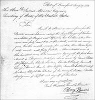
1814 Letter from Burns
In Jack Robinson's book, Captain Otway Burns and his ship Snap Dragon, he also included an 1814 request of marque and reprisal written from Beaufort, where Burns made his home and built a shipyard.

Thus Prometheus was built in 1818 in Beaufort, not in Swansboro as claimed.
_______________________________________

https://archive.org/details/captainotwayburn01burn
Walter Francis Burns' 1905 book online
Grandson Walter Francis Burns wrote:
"Captain Otway Burns married in 1809 a Miss Grant, daughter of Reuben Grant of Onslow County. By his marriage he had one child, Owen Burns, born in 1810, who became a lieutenant in the United States Navy. After the death of his first wife, he married December 4, 1814, Miss Jane Hall of Beaufort and for her a handsome residence was built in Beaufort near the spot where the Atlantic House Hotel afterwards stood; he resided there for twenty-two years. Burns' shipyard was in Beaufort. After Jane's death, he married Miss Jane Smith of Smyrna, N.C., on February 22nd, 1842, and moved to Portsmouth, N.C., where he lived until his death." (Captain Otway Burns - Patriot, Privateer and Legislator, Walter Francis Burns, New York, 1905)
_____________________________________

SYNOPSIS OF FAMILY 

FRANCIS BURNS, the immigrant, was born about 1710 in Glasgow, Lanarkshire, Scotland. He settled in the Onslow County area of North Carolina in 1734 and died about 1793. Francis and his wife Mary Otway had five sons: Otway (the father of Captain Otway Burns), Richard, Joseph, Frederick, and Jesse.

OTWAY BURNS SR., the elder, born about 1750, and unknown spouse were parents of Mary Ann Burns (born about 1780) and Otway Burns (1785-1850), both born in Swansboro, Onslow County on the family homestead overlooking Bogue Sound, near Queens Creek. On January 28, 1798, Mary Ann married John Sanders in Onslow County; they were parents of John, Otway Burns, and Eli Walter Sanders.

Captain OTWAY BURNS was born about 1785 on the Onslow County family plantation. On July 6, 1809, he first married Joanna Grant (-1814). Their only son OWEN BURNS was born in 1810. In 1814, Joanna left Otway Burns, with son Owen; she died that same year, leaving her young son with family for five years before Burns obtained legal guardianship of Owen. Owen served in the US Navy from 1834 until 1840. On November 18, 1849, their 39-year-old son Owen married 15-year-old Martha Ann Armstrong (1834-1913) of Baltimore.

On December 2, 1814, Captain Otway Burns' second marriage was to 18-year-old Jane Hall. They had one daughter, HARRIET HALL BURNS (1827-1882), who married Richard Cornelius Canaday on February 21, 1844.

OF NOTE: Descendants of Owen Burns have always denied that Owen had a half-sister Harriet Hall Burns. It is said that Owen hated his younger sister so much that when Otway went to sea, he arranged for her to stay in Onslow with the Canaday family. Harriet was raised by Cornelius Canaday and his wife Jane Bell, and ended up marrying their son Richard.

On February 22, 1842, after Jane Hall's death, Captain Burns married Jane Smith (1794-1859) of Smyrna, and moved to Portsmouth, N.C. where he lived until his death, October 25, 1850.
_____________________________________

Burns' connection to Beaufort's Old Town-New Town Boundary Marker - Northwest corner of Front and Pollock Streets

When established, October 2, 1713, Beaufort contained about 100 acres. To meet the requirements of a township, when incorporated in 1723, Beaufort was increased to 200 acres. 

The marker "indicates the dividing line between Old & New Town and was erected in place of a cannon which formerly stood here; said cannon being part of the armament of the U.S. Privateer Snap Dragon commanded by Cap't Otway Burns in the War of 1812-15." 


The Old Burying Ground cannon monument was erected by Burns' descendants. The unveiling took place July 24, 1901. Chief Justice Walter Clark was orator.  
 
Image from Walter Francis Burns' book
 

History of the Beaufort Plaque


Not long after the founding of the Beaufort Historical Association in 1960, then president Dr. John Costlow asked Miss Elizabeth Merwin to design a plaque to mark houses over 100 years old. The goal was to encourage interest in the townsfolk in preserving and promoting the significance of their historic homes. Classically trained in heraldry, Miss Merwin created a watercolor design—the same design in use today.

Many had been skeptical of the project as Dr. Costlow placed the first plaque on the Duncan House on the west end of Front Street, then dated 1790.* But, once it was in place, others began calling Dr. Costlow with comments such as, "My house is older than Sara's - why can't I have a plaque?" Soon, they began sprouting up all over town!
Thomas Duncan House

Producing the plaques eventually involved many people. Ben Jones cut a tin template to facilitate drawing the pattern on wood. Dr. Costlow traced and cut them out at the Duke Marine Lab on Piver's Island. Participating in the community effort, Bert Brooks assisted by applying seven base coats of white acrylic paint to the wooden shields. Dr. Costlow did the color work and lettering in his Ann Street kitchen.

In March 1963, the association announced that plaques were in place on 20 buildings, including the Duncan House, the 1796 Courthouse, the Old Jail, Carteret Academy and Purvis Chapel. Others included the Nelson, Easton, Caleb Bell, Hatsell, J. Davis, Beveridge, Morse, Piver, Gibbs and Langdon Houses. *See full list at the end of this post.

As more and more plaques were added, a few were done with a mellow gold and brown border to distinguish those houses from the 100-year-old ones. These few, having now ‘come of age’, may eventually be repainted with the traditional blue and silver border or owners may choose to leave them ‘as is’ due to their uniqueness. The one to your right is one of those with different coloration - displayed on the John Wolfe House on Orange Street.

A record of the significance of the plaque is recorded, but not documented, in Ruth Barbour’s "History of the Beaufort Historical Association." A research-only copy is available at the Beaufort Public Library. The below information is paraphrased with more details and images added:
 
  • The border of the shield-shaped plaque is made up of a blue and silver checked border signifying fair play. This compony (Heraldry adjective) border was taken from the Duke of Beaufort’s coat of arms which displays a single row of squares with alternating color.
  • The Red Rose of Lancaster at the bottom of the plaque represents the Lancaster lineage of the Duke of Beaufort’s family.
  • The gold menhaden at the top signifies “Fish Town," --the translation for what the Coree Indians called Wareiock--the name by which Beaufort was known in the early 1700s. *
    • *UPDATE: More research shows no documentation that "Fish Town" is a translation of Wareiock or Cwarioc, nor did a Coree village exist on the acreage that would become Beaufort. However, many years after Beaufort was established in 1713, the small village could have easily been referred to as "Fish Town" by those unaware of the actual name of the town. In fact, Cwareuuock, the reference to the Coree tribe on earliest maps included the Algonquian ending -euuock, roughly translated "people of" or "land of"--thus, the name Cwareuuock, on those early maps, referred to "Cwar," Core, or Coree territory. (Blair A. Rudes, UNC Charlotte, The First Description of an Iroquoian People) Until about 1706, the Coree occupied the peninsula and coastal area south of Pamlico Sound and the Neuse River, including what is now Carteret County. In Colonial Beaufort, historian Charles L. Paul wrote. "Before white settlers entered the area, the Coree had two villages. One of these was located on the north side of the Straits of Core Sound which separates Harker's Island from the mainland . . . The other village was located on the west side of Newport River."   
NOTES:
1) Sophia Merwin and her daughter, Miss Elizabeth Merwin, lived in the “Jennie Bell” house (306 Ann) for many years. (Widow Jennie McRacken Dill married widower William J. Bell. Jennie's daughter Sophia Dill married Nathan Merwin.) Elizabeth Merwin was born in 1918. She graduated from the Corcoran School of the Arts and returned to Beaufort in 1938 and worked on Piver's Island at the US Marine Fisheries with Dr. Herbert F. Prytherch. She still found time to make many significant and lasting contributions to her home town. She also designed the windows of St. Andrews Episcopal Church in Morehead City, and created beautiful coat-of-arms for several local families. Oddly enough, Elizabeth’s house at 306 Ann was not plaqued during her lifetime. It was plaqued when renovated and officially researched a few years ago—now the Buckman House circa 1848.
 
2) The Red Rose of Lancaster is the county flower of Lancashire. Rosa gallica officinalis is a small shrub producing richly fragrant, semi-double, rosy crimson flowers with prominent yellow anthers. The "officinalis" denotes the plant is used as an herbal remedy. The rose was first adopted as a heraldic device by the first Earl of Lancaster and became the emblem of Lancashire following the Battle of Bosworth Field in 1485. This ancient rose is recorded as being in cultivation in the 800s. It was used as a medicine and perfume in the court of Charlemagne in the ninth century A.D. Its petals were noted to retain their fragrance even when dried.
 
3) Beaufort has only one double-plaqued house. One plaque denotes The Allen Davis House circa 1774, home to the Davis family for over 100 years. The other is for Major General Ambrose Burnsides - Union commander of North Carolina troops during the Civil War. Burnsides had several headquarters in North Carolina and, though undocumented, it has been said that he used this home from 1861 to 1873, during the Federal occupation of the area.

March 1963 - First 20 Beaufort buildings to receive historic plaques
(Many dates have since been updated for accuracy.)

DUNCAN 1790 -105 Front St.; DAVIS 1821 - 127 Front St.
NELSON 1790 - 201 Front St.; MORSE 1771 - 215 Front St.
EASTON [HENRY] 1771 - 229 Front St.; SABISTON 1857 - 307 Front St.
CARTERET ACADEMY or Beaufort Female Institute 1854 - 505 Front St.
CALEB BELL 1770 - 817 Front St.; GIBBS 1851 - 901 Front St.
BUCKMAN 1845 - 114 Ann St.; BEVERIDGE 1841 - 123 Ann St.
PETER PIVER 1750 - 131 Ann St.; DAVIS 1817 - 201 Ann St.;
MACE 1832 - 619 Ann St.; WILLIS 1820 - 700 Ann St.
HATSELL 1827 - 117 Orange St.; LANGDON 1764 - 135 Craven St.
CRAMER 1796 (Courthouse moved to Restoration Grounds)
PURVIS CHAPEL 1820 - Broad/Craven
COUNTY JAIL 1829 (moved to Restoration Grounds)


*Author's Note: Please check these links to read more about the legislative act to establish Beaufort and a more accurate date for the Duncan House.